Pizza Den’s Submarine Sandwich

Frank Bowen sent me this recipe, and here I reproduce his original mail with the reminder that while the location has changed. Pizza Den is still open, and Bob’s family is carrying on the tradition of great local food in Oxford. Go see them the next time you’re there.

The following is a recipe that was posted on an Ole Miss Spirit message board several years ago. I made it several times and can attest that it is faithful to the original at the Pizza Den. It is not in standard recipe format, but it tells how to make the sandwich very well. I don’t know who made the post. He had a user name of Reblanta. I have found that the instructions of letting it rest on the counter for 15-20 minutes to simulate delivery is an important step.

Pizza Bob’s Famous Submarine Sandwich

In May, 1983, I had just bought a new car and decided that I would take it out on the road and drive up to Oxford for the afternoon, primarily to drop by Pizza Den and pick up some submarines to take back home and share with my Ole Miss friends that night. Things were slow late that afternoon when I got there but Pizza Bob was in good spirits. Since nobody else was there, I decided to broach the sacred subject on just how Bob made his famous submarine sandwich. Whether he was thinking of the good times he’d had in Nam, the money he had made off of me over the years, or perhaps he just felt sorry for me, I couldn’t tell, but this is what he told me. I watched him make the submarines and committed the process to memory.

Take your baguette, split it down the middle. Pour butter over the open slices of bread, sprinkle on a generous portion of both Parmesan and mozzarella cheese and place several thin slices of ham, salami, AND luncheon meat! Bob dusted all slices in between with the same cheese mixture, then in the middle of the meats he ladled in spaghetti sauce. Over the top of the meats he sprinkled more of the cheese mixture and then placed the other half of the bread on top. Finally, just as he was ready to seal up the sandwich in foil, he poured more melted butter over all. I cook mine about 20 minutes total in 350 degrees, turning it over about half way to disperse the butter evenly throughout. Finally, to make it authentic, take it out of the oven, and leave it on the counter top for about 15 to 20 minutes to simulate the delivery to Fraternity Row. Always remember to press the sandwich down as well.

I make it a point to make “Pizza Bobs” for every first televised football game of the year and I suggest that you do as well. I make mine exactly like he told me to except for that luncheon meat stuff. I hope that when you make your “Pizza Bob” sandwiches, you’ll think of Pizza Bob. I once heard this said and believe it now to be true: If food were a religion, Pizza Bob would be the High Priest.

Hometown Calhoun

Hometown Mississippi is an informative and entertaining book compiled by James F. (Jim) Brieger and published privately in 1980. It’s also an important work, since it includes all of Mississippi’s towns and counties of record, with a short write-up providing significant data. These are the entries for Calhoun County; Pittsboro, as county seat, is first listed, then the others alphabetically. Interestingly, the town of Heron on the map below is not on the list.

CALHOUN COUNTY

Organized in 1852, Calhoun County is located in the Sand Clay Hills Soil Area of the state. It was the fifty-ninth county to organize and ranks thirtythird in area. The county was named for John C. Calhoun, Vice-President of the United States, and at the time of formation, Henry s. Foote was Governor of Mississippi, and Millard Fillmore was President of the United States. Calhoun was the home county of Dennis Murphree, twice Governor of Mississippi, 1927-28 and 1943-44.

PITTSBORO

Pittsboro was founded on July 26, 1852 along with Calhoun County. The county seat was temporarily located at Hartfords, four miles east of the present site of Pittsboro, with monthly court being held in a log building which was used as a courthouse, Hartford did not remain for long as the county seat as the geographical center of the county was determined to be within a few hundred yards of Camp Springs,

On July 15, 1852, the Board of Police met at this point to discuss the matter of a permanent county seat, and Ebenezer Gaston, a wealthy local citizen offered 160 acres as a gift to the county for the location of a seat of government. The gift was accepted by the board and the proposed new town was named Orrsville, for J.A. Orr who had been very instrumental in the organization of the county. The name of the town was later changed to Pittsboro, for Pittsboro, North Carolina, which was Mr. Orr’s original home.

The Odom Grocery Store was the first building to be constructed, and in 1853, the Pittsboro Academy was established, being conducted in a two-story log building. In 1886, a frame building was erected to house the Pittsboro Male and Female College, then in 1888, Honorable B.J. Lowery, noted educator and statesman, taught his first school as principal of this college. The red brick courthouse was built the same year as the log jail, in 1856. In this courthouse the Secession Convention was held in 1861, and many other events connected with the war and reconstruction centered around it.

Pittsboro has had its times of prosperity and adversity, but has remained the county seat throughout the years, with many attempts having been made to move it, but all failed. In 1922 the courthouse was destroyed by fire, with the loss of almost all the records.

BANNER

Located eight miles north of Brice, Banner is one of the oldest existing places in the county, being settled by the Finn family from Ireland in 1840. The story is told, that Uncle Mickey Finn gave his reason for coming to America was the fact that land was so high in his native Ireland that he could not afford to buy a burial plot for his family. When he bought his land here and gave it the name, Banner, he immediately built a house, then he marked off a family burying ground,

Several large planters and slave owners were permanently settled here before the Civil War, and the town was known as a social as well as an educational center. A college was established in 1889 which offered commercial and music courses, but with the establishment of public schools the college became extinct. Since the start of the 1900’s, the place has been on the decline because of its remote location,

BENELA

The origin of its name is not known, but Benela was established eight miles southeast of Pittsboro in 1840. There were settlers here in the early 1830’s, but Benela was not founded until 1840 when Hugh Gaston came here with several others to establish business enterprises,

In 1853, Dr. S.T. Buchanan, Captain Enoch, Wiley and Austin Woodward settled here and Benela soon became a thriving trade center. In 1865 the town boasted six stores, two saloons, a large water mill and manufacturing plant. Being located on the Yalobusha River, cotton was transported to Greenwood by keel boat, bringing back supplies on their return trip. Lumber was also shipped down the river in rafts until the railroad was built to Calhoun City in 1905.

The growth of Benela was impeded by the fact that the railroad missed the town, and its rivals, Calhoun City and Derma gained the supremacy in leadership growth, and as trading centers, The Church, mill, and school were finally abandoned and the community became a farming area, using other points as trading centers,

BENTLEY

Bentley, located ten miles southeast of Calhoun City, was established in 1844 by Jesse H. Bently, the first settler, who erected a water mill on nearby Bear Creek. The town was incorporated in 1911.

BIG CREEK

Big Creek was founded eight miles west of Calhoun City in the 1840’s, The first settlers were R. Chruthird and Abram Sellers in the early 1840’s, being joined by other pioneers between 1845 and 1855. At this time Big Creek was located two miles north of its present location and was the distributing point for the sale of whiskey, with a wholesale house having been opened here,

Being so far from the railroad, the growth of the town was slow but with the building of the highway, two miles to the south, Big Creek was moved to its present location near the highway in 1920 with more stores being added and a post office being established.

BOUNDS

About 1824, J.R, Bounds, a cattleman, settled almost midway between the Skuna and Yalobusha Rivers, about eight miles west of present-day Pittsboro. His brother, Henry Bounds, joined him in 1828 and they found an ideal cattle range between the two streams. The two brothers rented this land from an Indian sub-chief named Bob Cole during their first two years of settlement, but later bought the land.

BRUCE

Bruce was founded in 1927 when the E.L. Bruce Lumber Company purchased a vast acreage in this section, four miles north of Pittsboro and established their large mill three miles north of Pittsboro in the Skuna Valley. The company purchased the Thurman Barton farm which became the home of George Rogers, Superintendent of the Bruce interests.

Johnny Main Mountain, six miles east of Brue, is the highest point in the county, covering several acres. Some remarkable rock formations are found on the mountain, and Skuna River flows around the base on the north side. According to legend, this mountain was the home of a prominent Chickasaw Chief named Piomingo at the time the Indians occupied this section. The mountain received its name from Johnny Main, an old Dutchman who hunted and trapped here during the 1860’s.

BUSYTON

Busyton was established about 1865, four miles south of Sarepta, and at one time a post office was located two miles to the southeast, but it was discontinued in 1905. Sometime after 1905, when State Highway 9 was improved, J.T. Ivy built a store on the highway and called it Busyton.

CALHOUN CITY

Federal Land Records show that the site on which Calhoun City stands, ten miles south of Bruce, was conveyed to an Indian named Ish tah hath la, T.P. Gore purchased an entire section of 640 acres from this Indian, supposedly for a handful of bright-colored beads, a few furs, and several quarts of whiskey. Being a large slave owner, Gore cleared a plantation and lived an easy life, in which horse racing and cock fighting figured prominently. Before his death he is thought to have buried a great amount of gold on his plantation, but died without revealing its hiding place. He is buried near Calhoun City in a wooded section of his former plantation,

In 1900 the Gore property passed into the hands of T.L. Beadles and Jeff Boland, being purchased from them in 1904 by Frank Burkett and J.S. Rowe. The place was named Burkett for Frank Bukett, but the name was later changed to Calhoun City for John C, Calhoun. These men learned that the Mobile & Ohio Railroad was planning to build a branch line through this section and made plans for the building of a town. One mile east lived two other landowners who were demanding that the terminal be located on their land. A legal battle was fought, and the court decided in favor of both places, so just one mile east of Calhoun City was established the town of Derma, Because of this matter, hard feelings existed between the towns cor several years.

The present town of Calhoun City was surveyed and laid off in lots in 1905. That same year, a hotel was built and a central parkway was laid out, awaiting the time when Pittsboro would relinquish its claim to the county seat and a courthouse could be erected.

The year of 1906 brought the incorporation of Calhoun City as well as many new families. On the first Sunday in January, 1907, the first passenger train ariived in Calhoun City. This was a great event in the history of the town and people, many of whom had never seen a train, came from miles around to witness the arrival.

DENTONTOWN

Located fourteen miles southwest of Pittsboro.

DERMA

In 1905, upon learning of the railroad to be built from Okalona to Calhoun City, Frank Burkett and J.S. Rowe immediately made plans for the establishment of a town in the vicinity of Calhoun City. Just one mile east lived J.M. Smith and Dr. S.H. Lawrence who also proposed to build a depot and town, Heated controversy resulted in a court decision in favor of both places, and soon there sprang up two rival towns. It is said that in time, Captain Burkett and Dr, Lawrence, both Civil War Veterans, were able to ease the friction between the two towns to a large extent. During the early history of the town, Derma enjoyed gradual growth which continued until the depression of 1929, at which time the town began to decline, The town also suffered several disastrous fires from which it never recovered, but at its peak, Derma boasted two churches, fourteen stores, and an Agricultural High School.

About four miles southeast of Derma is the site of the boyhood home of Fox Conner who was promoted to the rank of Major General by President Franklin D. Roosevelt. During World War I, Fox Conner was General Perishing’s fight hand man, and Perishing once stated that Fox Conner did more to help win the war than any one man he knew.

ELLARD

Located six miles northwest of Pittsboro,

ELZY

Settlers first came to this site, three miles north of Vardaman, in the 1840!s, and called the settlement Cherryhill. The place was later named Elzy, supposedly for B.M. Elzy an early merchant. A post office was established here in the mid 1850’s and was in operation until 1905. The village began its decline when the railroad was built through three miles to the north, and the railroad accommodations attracted most of the residents to Vardaman,

HARDIN TOWN

Hardin Town was established and named by Johnnie Hardin who came to this site, four miles east of Calhoun City, in 1845. The place also seems to have been known as Hopewell, since the post office, which was in operation from 1880 until 1903, and the school was known as Hopewell. Hardin Town was never much more than a one store settlement, and that became extinct during the depression of 1929.

HARTFORD

The extinct town of Hartford is historic in the fact that it was the first county seat of Calhoun County. Established in 1830, Hartford served as the seat of government from January until July of 1852, at which time Pittsboro, four miles to the southwest, was selected as the permanent county seat. Martin Murphree, Grandfather of Dennis Murphree, was one of the first settlers in this section, coming in 1835. A few years later Hartford had become a thriving trade center, with a furniture and jug factory being operated by 0. K. Bennet in the early 1840’s. Soon after the establishment of the county seat at Pittsboro, the town of Hartford began to decline, and by 1886 was an extinct village.

HOLLIS

Prior to 1860, Alexander Hollis and his brother, Marvin V. Hollis settled in this locality, three miles east of Derma and the place was named for these two brothers. Hollis was no more than a rural community until the building of the railroad in 1905, and it became a flag station. At that time a post office was opened and the town became incorporated in 1910. Hollis prospered for a few years but when the post office was discontinued in 1922 it began to decline. The nearby larger towns drew most of the trade and by 1927 the town was almost extinct.

LOYD

Located eight miles east of Pittsboro, the name origin is uncertain, but it is known that the community was settled before 1860. A post office was established at Loyd following the Civil War and in 1900 there were three stores in operation. The post office was discontinued in 1910 and mail was received from Vardaman.

MABRY

Mabry was a railroad switch located a short distance west of the depot at Derma. The switch served a large planing mill operated by G.C. and I. Mabry of Derma. Mabry became extinct with the abolishment of the switch in 1939.

PARTEE

Located seven and one-half miles west of Pittsboro,

PITTMAN

Pittman was established as a flag station on the Mississippi and Skuna Valley Railroad, twelve miles west of Bruce. The station was named for Sam Pittman who owned the land where the station was located before it was sold to the Bruce Lumber Company.

REID

It is thought that Young Phillips, who arrived here about 1850, was the first settler in this section, nine miles north of Vardaman, Other early settlers included the Hardins, Campbells, Morgans, and the Reid family, for whom the town was named. A post office had been in operation for several years when a store was opened by Tom Phillips in 1880. Three other stores were eventually built, and Reid enjoyed good business activity until the building of a railroad to the south in 1904. At that time the population began to shift to the railroad, business started to decline, and in 1910, the post office was discontinued.

RETREAT

About 1890, Stewart Warner opened a merchantile store near his home, ten miles northwest of Calhoun City, and in time, the settlement gained a post office which was named Retreat. Within a few years the post office was discontinued, and at that time the business of Stewart Warner was closed and Warner moved to Big Creek.

SABOUGLA

This settlement, located eleven miles southwest of Calhoun City, was first known as Davis Town, for J.W. Davis, who settled near here in the 1830’s. About 1880 when & post office was granted, the community was given the name, Sabougla for the creek on which it is located.

SAREPTA

Located eleven miles northeast of Bruce, it is thought that John Hellum was the first settler, coming in 1836 from Tennessee and acquired land a few miles north of the present site of Sarepta. Dr. Andrew Roane, son of Governor Archibald Roane of Tennessee, settled here in 1840 and at that time there was one store which was operated by a man named McLarty.

There is a story told of a happening in Sarepta, when in the 1880’s the backwoodsmen of the area had the habit of coming to town and taking the law in their own hands. It seems that a government man named Wise came to Mississippi in 1884 in search of a criminal. When he reached Oxford, he was reassigned to locate and arrest two brothers named Dock and Jim Bishop. The two brothers were wanted for the killing of two Harmon boys in a drunken brawl near Sarepta. Jim Bishop was finally located by Wise, who made friends with him, thinking that he could be persuaded to betray his brother. He gave Jim Bishop a bottle of drugged whiskey for his brother, setting a time and place for his capture.

Instead of betraying Dock, Jim betrayed Mr. Wise, and hiding behind a tree they ambushed him, filling him full of buckshot. They then buried him in a shallow grave where he was found a few days later. About three years later Dock Bishop was captured, convicted, and hanged for his crimes. A song, “The Ballad of Dock Bishop,” was then composed by one of the local citizens, and is probably still sung occasionally.

SHEPHERD

Located three and one-half miles northwest of Pittsboro,

SKUNA

Located six and one-half miles west of Pittsboro.

SLATE SPRINGS

Located nine miles south of Calhoun City, the place took its name from the springs located west of town on the Slate Springs-Grenada Road. The exact settlement date is uncertain, but it is thought by local people to be older than Pittsboro. If this is true, then Slate Springs could possibly be the oldest settlement in the county. Slate Springs appears to have been a trading center in the early 1800’s. At that time, in addition to the saloons, there were two stores, the first one probably being operated by a man named Woodward. Between 1880 and 1890, a post office, flour mill, and two churches were added. Also, at this time the Fox College was opened, with Fuller Fox as the first teacher.

TRUSTY

This small community, located twelve miles northwest of Sarepta, falls just within the county line. A store, in which was housed the post office, was given the name Trusty, for a local resident. The store as well as the post office have been discontinued, the Trusty family, along with other residents have moved away, and little now remains to mark the site of the settlement.

VANCE

Now listed as being extinct, Vance was located about two miles east of Slate Springs, being named for William Vance, who in 1837 was the first settler. After building a log cabin in 1837, Vance established a water mill on Shulispear Creek for the purpose of grinding grain. In 1844, Vance cleared a plot of ground about 300 yards from his mill on which to erect a larger home. He died before the home was built, and on being buried in the clearing, the spot came to be known as the Vance Graveyard, being used by the community which later sprang up.

For many years wheat as well as corn was ground at the mill, and during the Civil War and Reconstruction, this old mill provided bread for many people. Shulispear Creek was an ideal fishing spot, and people bringing their grain from many miles away would take advantage of the opportunity to camp for several days at a time, fishing and hunting while their grain was being ground. After William Vance’s death his son operated the mill for a few years, then it was sold and operated under the new owners until it was discontinued in 1914.

VARDAMAN

This settlement, four miles east of Derma, was originally known as Ticky Bin, and several stories have been told as to how the name originated. In those days the cattle grazed in the bottom lands where ticks were found, not only on the cattle but on the grass and trees as well. In 1872 a store was opened by Tom Richardson, but the chief industry in this section, especially from 1895 until 1903. was the stave industry. Handhewn staves were made all up and down the Yalobusha and Skuna Rivers, and at the time of the Paris World’s Fair, several staves were sent to the fair and received first prize.

By 1904 the community of Ticky Bin had increased in population and the need of a post office was realized by the citizens. The long hoped for railroad had. been surveyed so a petition was sent to President Theodore Roosevelt for the establishment of a post office to be named Vardaman, in honor of James K. Vardaman. The office was granted but was named Timberville instead of Vardaman as proposed. As the town grew, business firms, schools, and churches were established. The citizens, never satisfied with the name, Timberville, requested and was granted the name change to Vardaman.

Pearl River Revitalization: Two Lakes Still Stinks

This article, written well over a decade ago, contains information that still has relevance as what was once called the LeFleur Lakes project has been resurrected once again by proponents under the name of the Pearl River Revitalization Project.

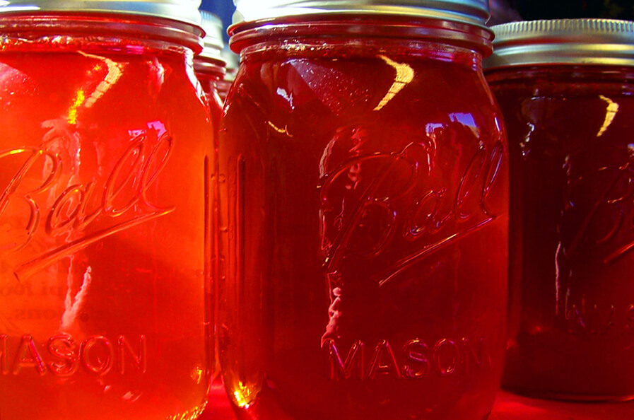
The Pearl River makes her way from a confluence of sloughy waters in the very heart of Mississippi to the marshy outskirts of the Gulf of Mexico in a graceful 500-mile arc. Lacking the majesty of the Mississippi, the cachet of the Yazoo or the utility of the Tombigbee, the Pearl is often cast as a poor relation; but she has played a significant role in Mississippi history, not the least of which has been putting Jackson on the map. In 1821, state commissioners decided that there was no desirable location within the required 20-mile limits of the geographic center of the state for the new seat of government, so they recommended a site “above the floods” of the Pearl River. In their report to the Legislature, the commissioners recommended the location of the new capital on LeFleur’s Bluff. They also suggested that the town should be laid out in President Jefferson’s design, a checker-board plan that stretched no more than a mile westward from the crest of the bluff where the new capital building would stand.

Initially, the Pearl River served the city as one of its earliest routes to and from civilization. The 1830s were a high water mark in the role of the river as a resource and a reason for the city, but by 1845, rail traffic had been established, and then roads rolled in from all quarters of the compass. Gradually the river fell into abeyance as a platform of commerce for the burgeoning city. But soon the Pearl came to assume a different economic role in the history of Jackson; the bluff could no longer accommodate all of its citizens and buildings began to be erected upon the floodplain. Flooding along the Pearl River in the Jackson area has been a problem since the beginning of the city, but it has been especially noticeable since development has spread into the floodplain. Since then, the river and its urban tributaries have flooded different areas on a periodic basis. Major floods have been classified by their severity according to the frequency at which they are estimated to occur. The 1979 flood has been called a 100-year floodplain event. The 1983 flood was a 50-year event. And the 1991 flood was a 10-year event.  It should not pass without notice that all three of these events occurred within a 12-year period.

Reservoir spillway under construction, c. 1960

Ironically enough, given this catastrophe of riches in terms of water, area leaders were discussing the problems of an adequate drinking water supply for Jackson as early as 1926. One of these leaders was State Senator Mitchell Robinson who succeeded in obtaining a flood control and navigability study from the U.S. Army Corps of Engineers. The study proved unfavorable, but Robinson was persistent. Some dismissed his idea of a dam north of Jackson on the Pearl to provide water and recreation for the city as “Mitch’s ditch,” others warmed to the idea. By 1955, Jackson’s water consumption had increased in excess of five times the rate of 1935 and pollution in the Pearl was a mounting problem. The labyrinth of legal and legislative problems and other obstacles that stood in the way of the construction of the Ross Barnett Reservoir are history now, and the reservoir is a pivotal element in the life of the city. But the Reservoir never was really designed for flood control; it was primarily constructed to create a water supply and to provide recreation. Despite that, the reservoir, because of its very nature as an impoundment of water, plays a crucial role in flood control in the lower river basin. According to Kenneth Griffin, general manager of the Pearl River Valley Water Supply District, the Ross Barnett Reservoir presents special problems in that area.

“One of the challenges, and one of the reasons this reservoir is so difficult to manage for flood control is that you have a huge watershed for this size river, this size of control structure,” Griffin said. “Regrettably, even with perfect hindsight, all you can do is to handle something like a 15- or 20-year event, depending upon when it comes. Certainly you can’t handle a hundred-hear or five-hundred year event,” Griffin added. “1979 was a really terrible flood, and we managed that one with very little in the way of rain gauges and stream gauges. We had manual rain gauges, cooperators that would simply call in the precipitation and we did not have any sophisticated software at that time. And even then, I think the people did a very good job, came very close to doing the best job possible.”

Local attorney Joe Kerley adds this footnote to the construction of the reservoir. “My Dad worked with the US Department of Agriculture, and was involved in the Rivers and Harbors organization. He attended meetings regarding the US Corps of Engineers and other federal and state entities involved in planning the reservoir. Our state could not fund a structure that would adequately control flooding. However, federal funds could have been provided so that the dam would be multi-purpose: flood prevention, drinking water and recreational. However, to obtain federal funding, the reservoir would have to be accessible to all citizens, black and white. Our legislature, as typical of the times, would not agree, and declined federal funding.

“Dad was livid about this,” Kerley said. “He saw the writing on the wall at that time and was sure the reservoir would ultimately accessible to all. There were many discussions about this at home in Hattiesburg, and with like-minded friends. But the legislature would not allow the federal funding, and this many decades we are still trying to figure out how to protect Jackson from the Pearl floods and the inadequate dam at the Rez.”

But even in the case of reservoirs that are designed to control flooding, the use of impoundments for this purpose has been discredited because of their downstream (and upstream) impact. Flood control reservoirs are set at a specific area in a drainage system to control flooding in an immediate area, but reservoirs impact rivers both above and below their dams. The LeFleur Lakes project is such an impoundment proposal intended to solve the flooding problems in the Jackson area in such a manner that “the attractiveness and growth potential of the metropolitan area would also be enhanced.” The proposal states that flood levels would be permanently lowered in the Jackson-to-Byram area by providing a better flow course for the passage of water and by reducing the rate of flow in the river and envisions the creation of a vital new waterfront district for the Jackson Metropolitan area.

Under the LeFleur Lakes proposal, large amounts of sand from beneath the numerous railroad and highway structures south of downtown Jackson would be excavated. This would be needed in order to provide the proper flow course through this area of the river. The study proposal maintains that existing levees and bridges presently block the river’s flow and back water up into Jackson homes and businesses. To accommodate the excavated material, the Flowood levee would be moved to the east and the dredged material would then be put in the middle of the newly formed lake. This would create a 600-acre island opposite downtown Jackson. North of Lakeland the dredged material would be placed on the east side of the newly formed lake. The newly-created land, an artificial island in the middle of the Pearl near where an extended High Street would stretch, would be accessed by bridges and by constructing interchanges of parkways and city streets over it and along the entire length of the 3000 acre lake. The LeFleur Lakes proposal states that “many roads and bridges are needed at this time to alleviate the metropolitan area’s traffic congestion,” and that both the traffic and flooding problems can be solved simultaneously and at less cost than plans for previous flood control, roads and bridges. The proposal also says that all the structures that flooded in the 1979 flood should be protected from another 100-year flood by the new lake and the improved reservoir discharge procedure. Additionally, the plan would provide that surveying be conducted in order to determine what structures exist in the various flood prone areas that would not be protected from a so-called 100-year flood. If any structures exist that need protection, auxiliary plans would be considered and, if warranted, additional protection would be extended to those structures.

The LeFleur Lakes plan would accelerate the flow course for the river by removing the trees from the very lowest level of the river floodplain (the river bottom land). This level would then be lowered another 5 feet with dredges and other earth-moving equipment, and then the entire 11-mile river course opposite Jackson would be made into a permanent lake. This lake would be necessary to prevent the redistribution of sand and silt and to prevent the regrowth of trees in the river flow course.  Naturally, the Ross Barnett Reservoir would play a key role in the project’s success. According to Griffin, “The LeFleur Lakes plan includes two components. Obviously, the lakes themselves are proposed. But the other half of the plan involves some major operational plans in how the (current) reservoir is operated, specifically how the gates are operated.” LeFleur Lakes admits to other drawbacks, as well.  For instance, under the proposal, levels in the Ross Barnett Reservoir, on two or three occasions each year, over a period of a day and a half, will fall one foot then rise again to their original level. According to the original Two Lakes website (now defunct), “Once every 25 years they (“Reservoir people”) would be warned to untie moorings and move boats because the level will be taken down below 295 feet. On the positive side, they would enjoy an extra one half to one foot of water in their boat slips” and “would be compensated by knowing that two thousand of their neighbors will never have to worry about their homes and businesses flooding again.”  In addition, metal buildings at very low elevations would not be protected from another 1979 flood, but they would be compensated by “having protection from a 100-year flood on structures that probably will not last 100 years.” People who own land and camps on the river south of Jackson would experience “one or two” river bottom floods that they would not have had otherwise, but they would be compensated by the assurance that the new reservoir would have the capacity to take one foot of elevation off of every major flood that could occur in the area. “One foot off of the 1979 flood would have prevented much of the flooding that these people’s neighbors suffered in 1979.”

Supporters of LeFleur Lakes cite the need some sort of flood control and the availability of direct funding for a local agency to undertake the project. Federal commitment to flood control in the Jackson area does exist; otherwise the Corps would not have sought funding for a more thorough and inclusive system of levees, a proposal now called the Comprehensive Levee System of 1996. In April, 1988 the Pearl River Basin Development District asked the Corps of Engineers to initiate alternative flood control studies. The Corps received authorization and funding in February 1989. Federal funds were used for the reconnaissance study which was completed in June 1990. The District agreed to serve as local sponsor for the study for the Jackson Metro area, which took 54 months to complete and cost $3 million. The District provided one-half of this amount in cash and in-kind contributions. A feasibility cost-sharing agreement was signed in September 1991, and feasibility studies were initiated in October of the same year.

The Pearl River Feasibility Flood Control Study (a.k.a. the Comprehensive Levee Plan) was completed by the Corps of Engineers in February 1996. The Corps recommended the construction of 21 miles of new levees at a cost of $122 million. The local sponsor would be required to provide $38 million for the acquisition of land, easements, rights-of-way, relocations and disposal areas. Legislation enabling the Pearl River Basin Development District to serve as the local sponsor for the Flood Control Project was defeated in the 1995 and 1996 sessions of the Mississippi Legislature.  The plan also included $30 million worth of recreation amenities and improvements, most of which would have been cost shared. Even before then, in 1984, the Corps also proposed a dry dam that would catch heavy flows from extreme rainfall events in the upper basin, events similar to those which caused the ’79 and ’83 floods. Called the Shoccoe Dam to be installed near Carthage, it was planned at a cost of $80.1 million ($24 million shared). It was identified by the Corps of Engineers as the most comprehensive flood control project for the Pearl Basin. But in October, 1984, the Mississippi House of Representatives defeated a bill authorizing the District to serve as the local sponsor for Shoccoe.  Local opposition killed the funding measure, but many people still consider Shoccoe to be the best plan for flood control in the middle reaches of the Pearl.

Everybody has their favorite proposals. “As far as we know, the Comprehensive Levee System (proposed by the Corps) is still viable, but we’ll have to evaluate it again,” Walker said. “We will have to see if the levee alignment is still in place, and we’ll have to see if any development has gotten in the alignment and we’ll have to adjust it.”

“What we’re looking at are the levees and LeFleur Lakes. It’s probable that LeFleur Lakes might turn out different than what it is now. The final result might be some combination of lakes and the levee system. We have several of what we call milestones that we’ll reach as we go through the study. We’ll discuss these with the sponsors, since these will be decision points where we’ll decide whether we need to go forward or not. If we get to the point that something showed up as a “show-stopper,” we would have to evaluate with the Levee Board at that time whether we want to proceed with that plan or do something else. But we could not proceed without them being agreeable to that. There is a consensus that something needs to be done, but the question is what the plan is on how to control it. Public opinion is such that something is needed to control flooding, but we don’t know what the plan is. As to other proposals, as we go through the process, a sponsor will have to sponsor a study for other alternatives. With the proper sponsorship, other plans could be submitted.”

* * * * * * * * * *

The Pearl River Basin covers an area of about 7,800 square miles, comprising about 16 per cent of the state as a whole. From Neshoba County, the river flows southwesterly, eventually forming the boundary between Louisiana and Mississippi in the southern part of the basin and discharging into the Gulf of Mexico just north of New Orleans. Before the Pearl reaches the Gulf from Jackson, it still traverses some two hundred plus miles, and the lands along the lower river have already felt the impacts of impoundment and flood control in the Jackson Metro area. One of the most serious effects is that of bank erosion, which has been a crucial and continual problem since the development of the state. Andrew Whitehurst, a wildlife ecologist with the Mississippi Museum of Natural Science, is the author of the newly-published Mississippi Streamside Handbook, available as a free download from the Mississippi Department of Wildlife, Fisheries and Parks website. Whitehurst said that rivers are able to carry a great amount of sediment. But when a stream goes into a reservoir, it slows down and the energy of the water is dissipated. Much of the suspended material it carries drops out, and the water leaves the reservoir sediment-starved.

“A normal river will gather a suspended load from its bed and from whatever flows in from its tributaries and through normal bank erosion and moving sand bars around,” Whitehurst said. “Our river (the Pearl) is altered. The fact that the discharges can be abruptly stopped after a flood event makes the levels go up and down, so the banks become saturated during floods and when the water is quickly shut off and the level of the river channel drops, the banks can slough or heave.” Whitehurst points out that there are three well-known diadromous (migratory salt-to-freshwater) species that will be impacted by the dams: the American eel, the Alabama shad and the Gulf sturgeon. The maritime connection of the Pearl is another crucial element when flood control anywhere along the river is under consideration, since the wetlands that lie near the mouth of the Pearl are important to the seafood industries along the central Gulf.  In a public hearing in Biloxi on March 11, coastal residents expressed concerns that LeFleur Lakes would damage the Coast, especially in terms of the area’s seafood industry. Gulf citizens were particularly worried that the project would reduce the amount of fresh water flowing into the Mississippi Sound, degrading its oyster beds and shrimp population.  Lauren Thompson, of the Mississippi Department of Marine Resources, said, “Our concern is with reduced or increased salinity as well as with sediment and nutrient transport down the Pearl River. The reduced flow of nutrients and sediments down the Pearl can change the environmental conditions in the Mississippi Sound, affecting salinity and water quality.

“So it could have a negative impact on oysters, shrimp, blue crabs and finfish. Oysters, which can’t move, have a narrow salinity band. If the salinity is too high, predators come in; if the salinity is too low, the oysters close up, and if they stay closed for an extended period of time, they die.” Since the Pearl empties into the Gulf just north of New Orleans, the State of Louisiana is also keeping an eye on flood control along the river, as it will impact their seafood industry as well as salinity levels in LakePontchartrain.

The Pearl River levee system.

Apart from the Reservoir, flood control in the Jackson area is also managed by a system of levees built by the Corps of Engineers in the 1960s. These levees serve as buffers for the floodwaters and also funnel the flood downstream. Aside from emergency situations, the levees are largely maintained by local interests. Periodic inspections of maintenance are made by personnel from the U.S. Army Corps of Engineers and from local levee and drainage districts, in this case the Rankin Hinds Pearl River Flood and Drainage Control District, also known locally as the Levee Board.  This board has been given broad powers to deal with flood control along the Pearl River in Rankin and Hinds Counties. The board is made up of the mayors of Richland, Pearl, Jackson and Flowood as well as the head of the Mississippi Development Authority, Leland Speed, in his role as representative of the Mississippi State Fair Commission. Robert Stockett Jr. represents Hinds County, and the chair, Billy Orr, represents Rankin County. The board itself is funded by the Boards of Supervisors of Rankin and Hinds Counties.

There are fourteen miles of levees in the Jackson area that protect flood lands in Flowood, practically all of Pearl and those in Richland. They also protect those lands below the bluff around the fairgrounds on the Hinds County side of the river. The levee board has taxing power on property that is protected by the levees. If you own a business or property that is protected by a levee, then you are taxed by the Board to help pay for the maintenance of the levees as well as pump maintenance and levee patrols during flood times. The tax revenue brought in by the Board totals less than a half million dollars. The Corps and the Levee Board have agreed to initiate a three-year, $2.8 million feasibility study that will be limited to updating the cost of the 1996 levee plan and a complete analysis of the LeFleur Lakes Plan. “We don’t have a set schedule for reviewing the progress of the analysis,” Orr said, “We have other things to do, but the Corps will be on it daily and we’ll keep up with it very often. We do keep up to date on it, and it is our responsibility to make sure it goes right. Whatever the requirements are as these studies go along, we will meet as often as necessary.” Orr said that they follow the Corps’s recommendations in matters of maintaining the levees and that while some people might claim that they are more partial to one flood control plan over the other, “We will be partial to LeFleur Lakes only when it has been studied and it has been proven that it can do the job.”

The decision to put the LeFleur Lakes Plan in the hands of the Levee Board was made by the three county governments of Rankin, Hinds and Madison Counties as well as the governing bodies of eleven cities in the three county areas. Purportedly, they will expand the district and build some version of the project. The levees will be incorporated into the LeFleur Lakes strategy, since the levees were part of the original “Two Lakes” plan.  According to Gary Walker, project manager for the Corps of Engineers, “The EIS (environment impact statement) draft (for LeFleur Lakes) is scheduled for October, 2005 and it will take about six months after that for the final. The recommendation will be a joint process between us and the sponsor,” Walker said. “It will be a plan we both can agree on, it will be a joint recommendation between us and the Rankin-Hinds Pearl River Flood and Drainage Control District. We’re doing a full evaluation and the study will determine how we assess the project. We’re not going to make any pre-determined notions. The study will speak for itself.”

As to alternatives to LeFleur Lakes and the comprehensive levee plans, no others are under consideration, since Walker said that the Corps can’t recommend anything without a sponsor. But “assuming we went through the process and found a feasible plan and a sponsor, yes, we could approve (an alternative).”

“People ask how long it will be before a flood control plan will be put into place,” Orr said. “But we don’t know how long it will take. The study itself is going to take two and a half years. After that, it would be left up to funds that are available, and this project (LeFleur Lakes) is big. Now, it might not come to anything, because environmental concerns might knock it down or something else like public sentiment or lack of funding might come into play. The only thing I can say is that this board would like for the LeFleur Lakes project to be a reality if it does the job in controlling flooding. The only thing we’re interested in is flooding. Economic development and all the other factors do not interest us. Our job is flood control, and if this project does not meet the required specifications, it will be gone. I’m sure there’s room for modification,” Orr said. “With all the study and money going into this, we hope something will come out of it that will work. The only thing for sure is that Rankin and Hinds Counties need some flood control assistance somewhere. I was head of the Fair Commission in 1979 during the Easter Flood and we lost over $2.5 million, and that’s a lot of money.”

* * * * * * * * * *

In the final analysis, until people begin to perceive of the Pearl as a resource rather than as an obstacle, LeFleur Lakes, or some similar project involving development along the river that will control flooding and perhaps create revenue, will continue to receive a lot of support in the Jackson Metro area. But we do have other choices. Metro Jackson can either preserve the riverfront with options that have the potential to appeal to a younger, more aggressive entrepreneurial population while continuing to promote more downtown development, or the city can align itself with political and business leaders who seek to develop the riverfront at great expense and create a new district that will in all likelihood fail within the next decade or so, benefiting nobody save those who developed (or dredged up) the property in the first place. Supporters say the LeFleur Lakes idea is just a different approach from the levees, one which has the economic development and recreational components that levees just don’t have. They also cite the support of local governments, state agencies and the congressional delegation. John McGowan, the Jackson entrepreneur who originally conceived of the LeFleur Lakes (then called Two Lakes) plan, declined to comment on the evaluation in a telephone interview and deferred comments on the project to the Levee Board.

Detractors of LeFleur Lakes tend to focus on the negative environmental impact the project will have, but not necessarily in the sense that it will endanger already threatened species of wildlife. These detractors cite numerous studies showing that in addition to education and other quality-of-life issues, aesthetics and recreation are important to young entrepreneurs, especially younger business owners who are looking to relocate. They point out that LeFleur Lakes is going to destroy the wetlands and natural resources that are in the corridor, the same resources that in other parts of the country, smaller urban areas use to provide green space for recreational opportunities that appeal to people oriented towards activities carried out in natural settings, like hiking, biking, jogging and nature viewing.

Pearl River swampland

These critics feel that the LeFleur Lakes project is simply not progressive enough and does not address the changing demographics and mindset of the 21st century South. In this context, the controversy surrounding LeFleur Lakes becomes a conflict of perception about the way Jackson should move, about the best venues that the city can take in order to become a more vibrant community rather than a battle between tree cutters and tree huggers.  As an alternative to both LeFleur Lakes and the comprehensive levee system (which unlike LeFleur Lakes included green space facilities), proponents of green space, who include local businessmen as well as conservationists, are proposing a greenway that will transform what is now a denuded floodplain into an area that will feature hiking, biking and jogging trails, parks with sports fields and playgrounds, a scenic river corridor for boating as well as wilderness areas. Jackson geologist Dan Hill is among those who maintain that the greenway proposal has the potential to increase city revenue by attracting young professionals and entrepreneurs who look for such things as aesthetics and outdoor recreational activities when seeking to relocate.  “The Levee Board has denuded the area between the levees to improve the convenience of the flood waters out of the flood zone,” Hill said. “The Levee Board maintains the levees and the floodways such as the areas at Lakeland and I-20. They clear the floodways rather than do any aesthetic features and it’s ugly.”

“When you clear the trees away from the river, there are no roots to hold the banks,” Hill said. “The reason they clear the trees is that those trees and vegetation create a drag on the water going through, so what they do is straighten up and dredge the channel as it has been along I-55. That improves the passage of water. One of the things that the Mississippi Department of Wildlife, Fisheries and Parks didn’t like was the clearings in the 1996 plan, which would have increased the number of clearings. It’s ugly; it looks like a moonscape going across I-20. And this creates a negative impression about Jackson.”

The greenway proposal is problematic because it can’t control flooding along the river and has limited appeal for those who are unaccustomed to more nature-oriented forms of activity (biking, hiking, kayaking, etc.) and are more acclimated to the hustle and bustle of a more people-oriented environment; shopping malls, for instance.  But the environmental issues are still crucial. Water quality is a primary concern. According to Jackson businessman Jerry Litton, “If you look at the area that will be draining into LeFleur Lakes and look at the trash and debris that flushes from the city every time we have a rain, that is what the water in those lakes is going to look like.”

“Debris will collect on the edges of the lake, or collect on drifts that are out in the open or on the edges of the (proposed) island,” Litton said. “It’s going to be there, and somebody’s going to have to float around in a boat in a net and dredge it out, all of the stuff that comes down from the spillway itself, plus what flushes out of the creeks in the city.” Nonpoint pollution is also a consideration. Nonpoint pollution is source pollution, or “polluted runoff,” created when rain, irrigation and other water sources run over the land, picking up pollutants and transporting them to local water bodies. You’re going to hold water there in a large volume, and you’re going to have all the nonpoint pollutants that come from the city. Nonpoint sources are parking lots and roadways and fields. Then what about all the motor oil, paint and paint thinners that people won’t take the time to take to the toxic waste centers? It’s being poured down storm drains.”

Hill agrees. “The shallowness of the proposed reservoirs (LeFleur Lakes) is such that water temperature is going to heat up and that’s going to affect water quality. Not only that, but when they impound the lake they’re going to flood one landfill that I know of, and there’s probably a second landfill. I found out when they tore down the old Baptist hospital, they put the asbestos from that in a fill that would be flooded.”  Sewer mains are another concern for the LeFleur Lakes project. Broken sewer mains would flow directly into the lake from the city. One such sewer is the West Main Intercept, which drains north Jackson and travels through the floodway. The construction of a lake in the floodplain opposite Jackson would put that sewer main underneath the lake itself. Environmental issues aside, when it comes to local sentiment, the LeFleur Lakes proposal appeals to a genuine need for the people of Jackson to feel as if they are living in a vibrant, growing community that is making changes and improvements. In addition to the attractions of proposed flood control and potential economic benefits, LeFleur Lakes has come to represent an alternative to apparently ineffective downtown development. Granted, LeFleur Lakes appeals more to the outlying metro area than it does to the city itself; on the surface, the project has much greater appeal for those sections of Ridgeland, Hinds and Rankin Counties between the spillway and Byram, but it still has its supporters in the city itself, not the least of which is former Jackson mayor Harvey Johnson Jr.

“The continuing flooding we experience nearly every year undeniably demonstrates that we very much need a comprehensive flood protection plan,” Johnson said. “As a member of the Rankin-Hinds Levee Board, I work closely with mayors from Rankin County and other board members to address ongoing flood control measures.”

“The public has rallied around the LeFleur Lakes project as an alternative to levees. The City of Jackson has gone on record as being in support of the LeFleur Lakes project, and we continue to work closely with federal, state and other local authorities to come up with the right answer to solve our problems with floods. We will continue to evaluate the LeFleur Lakes proposal as it evolves while we decide the best ways to provide flood control,” Johnson added.

“The problem with any development on the Pearl is hydraulics,” Litton adds. “Up to 1959 – 60 the river mostly only rose up to 28 or so feet crest. After the resevoir was built and levees it has gone up to 43 or so feet. Problem with this is it does not go up appreciably in the upper and lower reach as it does here. Why? Levees, reservoir, urban development and the unknow fact, the Pearl has a fifty or so mile long crest when it gets up. Check the data or the 79 floor. From the dam to about Rockport the crest was almost flat at 43 feet. Oddity, no sir, it is the hydrological sequence of hard bottom, forest shouldered edges, a narrow girth and the necessity for the river to get up this high to push the water through.”

But according to Matthew Dalbey, assistant professor in the Department of Urban and Regional Planning at Jackson State University, “From a physical planning point or perspective, when you have an interstate between a new development project and downtown, I don’t see how that is going to help downtown. As a matter of fact, I think it’s going to make downtown dead. It’s just too big of a separation; it’s just like any other type of leap-frog development or urban sprawl. The people who argue for this will say that any new development within the boundaries of the city will provide a positive economic impact, but the issue remains that the new development will be separate from the old development. It will kill downtown because of the separation. I think that there’s a tendency to support new development by local people, so for instance you can get a premium rate for something new whether it’s strategically located or not. In other words, there’s nothing new downtown, so people aren’t investing downtown, but take the Fondren Corner building; it’s a redone building in an area that had formerly been in decline,” Dalbey said. “But the new investment in that place has been such that they can get a premium on the rents there. As a matter of fact, Fondren is in a rebound, and people like being there.”

Of course, it’s questionable whether LeFleur Lakes, or any such new development district will improve the local economy. Some people are of the opinion that the city has extended itself already and that further development is superfluous; after all, the state economy is drawing back, consolidating itself and trimming edges, so it makes sense that the capital city should follow suit.  Under scrutiny, LeFleur Lakes appears to be an antiquated development concept that creates more problems both in Jackson and downstream than it solves. Jackson deserves a solution to flooding that is effective and progressive, one that focuses on enduring issues rather than quick-fix alternatives.  We need protect ourselves, but we need to take care of our river, too; after all, she’s why we’re here in the first place.

The Last Mississippi Spa

Almost twenty years after Allison’s Wells burned in 1963, O.C. McDavid, former managing editor of the Jackson Daily News and a noted sculpture artist, was approached by Hosford Fontaine to assist in a book with recipes. In turn, McDavid enlisted Marilyn Bonney, who owned Press & Palette in Canton Mart, to print the 68-page book. According to Marilyn, “I printed it using paper plates which were a one-time use. I don’t remember the exact number printed, but it was probably1,000. The plan was not to sell it, but O.C. and Hosford gave it to people they knew, and I did the same.” In a similar spirit, with hopes of perpetuating Hosford’s wonderful work, here’s Allison’s Wells: The Last Mississippi Spa by Hosford Latimer Fontaine.

The Last Mississippi Spa

A Shroud for the Ivory-Bill

In 1943 Mississippi Governor Paul B. Johnson, Sr. along with the governors of three other Southern states—Sam Jones of Louisiana, Prentiss Cooper of Tennessee, and Homer Adkins of Arkansas—joined in an action that remains unique in the annals of American history: a last-ditch effort to save a species from extinction.

Magnificent in flight, majestic in repose, the ivory-bill was the largest woodpecker in North America, second in the world to its closest relative, the imperial ivory-bill of Central America and the Caribbean. The ivory-bill at first sight is said to have caused newcomers to the primeval woodlands of the South where it once lived to exclaim, “Lord God, what is that thing?!”

As the vast virgin woodlands of the South fell to the axe during the late 19th and early 20th century the ivory-bills, which required extensive tracts of timber to survive (an estimated 2.5 square miles of old-growth forest for a mating pair), began to starve.

By the first decades of the 20th century, only one sizeable portion of virgin Southern woodland remained intact, an area of dense mixed long-leaf pine and deciduous trees that stretched from the Brazos River in Texas to the Tensas in Louisiana. Once covering over 2 million acres, by the 1930s the “Big Thicket” had shrunk to a mere 800,000.

In an an odd twist of fate, an extensive section of this forest had been purchased by the Singer Sewing Machine Company to secure hardwood for machine cabinets. This, the so-called Singer Tract, was the last documented home of the ivory-bill, and the fate of this splendid bird indeed hung by a thread. In 1937 Singer sold the logging rights to the Chicago Mill and Lumber Company, and in the next year cutting began. Under the agreement, land logged by Chicago Mill and Lumber became that firm’s property, but until then, the Singer Company still held ownership.

The survival of the ivory-bill became a subject of national consideration (a significant gesture during the war years) involving not only the four aforementioned governors, but President Roosevelt, the Secretary of the Interior Harold Ickes, the directors of the National Forest Service, the Fish and Wildlife Service, the War Production Board, and the National Audubon Society.

In December of 1943, the chairman of the board of the Chicago Mill and Lumber Company met with the brokers of a potential land deal that would have established a national park and refuge for the ivory-bill. The other participants were Louisiana’s conservation commissioner, the refuge director of the U.S. Fish and Wildlife Service and their attorney John Baker.

But despite the offer of $200,000 from the state of Louisiana to purchase the remaining Singer Tract, James F. Griswold, chairman of the Chicago Mill and Lumber board, refused to deal. In what is perhaps the ugliest and most blatant admission of corporate greed and irresponsibility in the history of the United States, Griswold said, “We are just money grubbers. We are not concerned, as are you folks, with ethical considerations.” In a similar vein, Singer Company treasurer and vice president John Morton told Baker that Singer “didn’t care.”

Subsequent offers proved fruitless, and the Singer Tract was clear-cut (by German POWs, no less), creating a wasteland of baked mud studded with stumps, sending the Lord God bird over the abyss into certain extinction.

The Yellow Rose of Schoona

A poignant tale of love, loss, and thralldom embellished with romance as tales often are, this story was published over a century ago in The Calhoun County Monitor-Herald.

In the cold, dreary winter of 1852, just after the organization of Calhoun County, quite a number of citizens of Spring and Brushy Creeks were sitting in a rude log cabin by the roadside, where John McCord kept a store, lightly stocked with the necessities of life, discussing the new county and squirting tobacco on the old, rickety stove. Bob Brown, the Postmaster, (for there had recently been established at this place a post office called Banner), came around and stood in the door. Snow and sleet were falling thick and fast and the cold north wind howled through the towering pines and drifted snow against the rude fences. All nature seemed at war–and the howling storm quelled the spirit of those pioneers, who were acquainted with trouble and knew danger and privations.

“The coldest day I ever felt,” said Bob. “Everything outside is freezing.”

While the men were buttoning up their coats, preparatory to breasting the storm en route to their homes, Bob looked eastward along the road and saw a lone woman trudging through the snow storm, coming in the direction of the store. She soon appeared at the door and asked permission to warm at the fire. The gentlemen gallantly gave way and tendered her a seat near the stove.

“Bad weather to be out,” remarked McCord, the merchant. “Quite unpleasant,” replied the woman in soft, sweet voice. She was well and comfortably clad, and had in her hand a well filled grip. She was tall and well formed, with a handsome figure and soft, appealing eyes. Her hair was long, dark and wavy, and her skin was a soft yellow–not quite as dark as the Indian. Her features were animated and her countenance sparkled with every change of expression. Her step, quick and elastic; voice, soft and musical; her language, pure and faultless English and her age about 22 years. The men soon started for home through the drifting storm, and left McCord, Brown and Sid Brantley and the woman still clustered about the stove. The able, big-hearted Brantley asked the woman how it happened that she was caught out in the storm, and where she was going in all this bad weather.

After some hesitation, she answered in a low, musical voice, “I am part Indian and I am making my way to the Indian Nation, where my tribe, the Chickasaws, went in 1836. I was then a small girl living with my grandmother. My mother, a Chickasaw died when I was a baby. My father, a white man, went with the tribe. My grandmother, being very old, was left with me. After grandmother died, I was taken by a nice family of whites, who gave me a home, taught me the art of dressmaking and educated me. But I could not forget my brothers and sisters in the Indian Nation and at last resolved at every hazard, to make my way to them. I have no money or friends that I can call upon for assistance, so I am trying to make my way afoot.”

Her simple story touched Mr. Brantley’s heart, and he cordially invited her to his nearby home. She, with some hesitation, accepted his generous invitation and accompanied him home, where she remained until the storm was over. In conversation, on the way home, Brantley asked her name. She modestly answered, “Bombazelle McAllister”. She was introduced to the family and assured that she could make her home with them until the weather settled. She was assigned a room with Brantley’s oldest daughter. The next day was still cold and blustery and the ladies were confined to their rooms. The stranger soon became familiar with the family. Miss Brantley had a nice new dress pattern she was preparing to make up. Bombazelle examined the goods with great care and suggested how it should be designed. Sissy was delighted. Bombazelle took her measure–a thing heretofore unknown in these wild woods–and she assisted in making the dress. The family was delighted with the attractive design and the gracious fit of the dress. Hence the news spread rapidly throughout the neighborhood that a marvelous designer and dressmaker was stopping at Sid Brantley’s–and the blushing lassies in all the region gathered ’round to have Bombazelle cut and fashion their dresses. She moved from home to home as her services were requested, and at night, occupied rooms and beds with the young ladies of the community.

The snow storm had passed, but Bombazelle remained, kept busy cutting out and making dresses. She was well paid and was kindly received by every family. She was ready and willing to give the young ladies instructions in cutting materials and in dressmaking. She was a fine talker and a lovely girl, her color rather dark, but being part Indian, this was understood. She soon became the Belle of Banner, and the boys called her “The Yellow Rose of Schoona”, and she received the attention of all the nice young men in the neighborhood. John McCord fell desperately in love with Bombazelle, and after a spirited contest with the young swains about Banner, won her heart. McCord was, as the term was known in those far-off days, “well-off”. He had a good house, servants and quite a number of Negro slaves. The couple was married at Brantley’s home, Esquire John Hankins making the happy couple man and wife. There was quite a gathering at the wedding, and, as was the custom, all who wished, were privileged to kiss the bride, as did some of the girls and women present.

The springtime in all its beauty was rapidly approaching. The dogwoods were budding, the birds were all a-twitter and the geese were flying north to their faraway homes. Bombazelle was happy in the home of John McCord. She had a husband who was a leader in the young county and was loved and admired by everyone. She also had Old Sylvia, her trusted servant, and her flock of boys and girls, to attend to her every want. She kept a close eye on the servants, and they had to “toe the mark”. She had her rooms well furnished, wore wonderful clothes, and kept everything about the place in “apple pie” order. Every servant jumped when she spoke, for she was a firm mistress, and ran the house with energy and ability. McCord, too, was happy with his beautiful wife and his elegantly arranged home. The “Yellow Rose” was happy and excited because she was the leader in style and fashion in the whole county. She was constantly sought out and consulted about dresses and was a close friend to the young belles for miles around.

Spring opened in all its glory. The whippoorwills sang at evening, the sun smiled all day on the new fields, just wrested from the primeval forests, and the birds and animals made love in the swamps and endless forests. Late one afternoon, a fine looking gentleman was seen riding a splendid blooded horse into Banner. Mrs. McCord (Bombazelle) observed him–and, in consternation, made it convenient to disappear at once. The traveler alighted and entered the saddle shop owned by J. Brown, and after passing the compliments of the season, inquired if there had been seen in that place a woman who had disappeared. He gave an accurate description of Mrs. McCord. Bob hesitated, looked wise and gave an evasive answer. Night was approaching, so the stranger asked if there was a house of entertainment in town. Brown directed him to Mr. Arnold’s home, just west of town. He made his business known to Mr. Arnold, and said he had traced the woman to Banner–and that she was his Negro house servant and seamstress–and that she had run away from the family home at Aberdeen, Mississippi. Arnold repeated to him the story of Bombazelle’s appearance, her captivation of the community and her marriage to John McCord months before.

“That’s my Negro,” said the stranger, “she is almost white in appearance and is very smart.”

It is hardly necessary to add that the people of Banner were stirred up and greatly excited by his revelation. The belles and beaus were crestfallen. The girls who had entertained and associated with Bombazelle were dumbfounded. The idea of having so cordially entertained this servant in their homes was humiliating. And the young men who had called upon Bombazelle and sought her hand were shocked beyond expression while the older men, who had so fondly kissed the yellow blushing bride, were punched in the ribs by their wives for having embraced the woman in their presence. But the “Yellow Rose”! Where was she? McAllister (the stranger) could not find her anywhere. She had suddenly and mysteriously disappeared. McCord was wild and miserable. His happiness was swept away in the wrinkling of an eye. Dispirited and troubled, he stood about, wondering what to do! His wife, with his knowledge, had been secreted in a cabin on Schoona, there to await the issue. McCord was a good man, law-abiding and honest, yet he did not know but that McAllister was a fraud.

McAllister posted off to Hartford (the community now known as Oldtown, which was the county seat at that time), here he learned that the marriage certificate had been issued to John McCord and Bombazelle McAllister, and that it had been returned by Esq. Hankins. He at once instituted suit against John McCord and his securities, for marrying a Negro, contrary to the laws of the State of Mississippi. McCord’s friends were in close consultation all day, devising ways and means to extricate McCord from his dilemma. Brantley, with a keen eye to business, also went to Hartford, and there met McAllister. Brantley, being always a friend for anyone in distress, had a long interview with McAllister, and induced him to suspend legal proceedings until he could see McCord, assuring him that it was a fraud practiced on McCord, and McCord truly believed that she was part Indian, but had never dreamed that she was a runaway slave–and that she would be found and returned to McAllister. Old Sylvia was the happiest Negro in the county. She and her children clapped their hands at being relieved of such a hard head mistress.

Brantley returned to McAllister that afternoon, after having a long talk with McCord and Brown, entertained him that night and promised him that Bombazelle would be forthcoming in the morning. So, in the morning, bright and early, “The Yellow Rose of Schoona” fondly embraced Mr. McCord, bid him an affectionate farewell, and promptly reported to her master, and they departed for Aberdeen.

Editor’s Note: [1972] In the 1940’s, Dr. W. A. Evans of Aberdeen researched The Monitor Herald story of Bombazelle McAllister in the county courthouse records at Aberdeen. He found advertisements by the man McAllister, giving notice that his slave Bombazelle had run away. After McAllister took her back to Aberdeen, he sold her at once, as she had given trouble before. The money paid for Bombazelle went into the building of a new McAllister home, located in the city of Aberdeen. Dr. Evans reported that no further evidence of Bombazelle exists after she was sold.

Daddy at the Movies

Jess Jr. was an expressive soul with little reserve, a candor celebrated by many, but trying for my mother. It was especially difficult when they went to the movies, since my father’s tastes in films ran to maudlin melodramas.

She said he would hear about these movies from a slew of waitresses, secretaries, and beauticians-–Daddy never passed a beauty parlor without going in; he said it caught the girls at a disadvantage-–who kept him up with the latest Hollywood tear-jerkers. He’d drag her to see films such as Peyton Place–“It’s bad Faulkner!”)–Hush, Hush, Sweet Charlotte (Daddy had a lot to say about the legal issues in that one)–and Madame X. During the courtroom scene, he said loudly for the entire theater to hear: “My God, can you imagine what she must be going through!?”

Mother simply stared with resignation at the screen, studiously avoiding chilling glances. Some scenes reduced Daddy to great heaving sobs, like when they had to pull Susan Kohner off Juanita Moore’s coffin at the end of Imitation of Life. His only child to inherit this sense of cinematic drama was my sister, Cindy, who bolted out of a Memphis theater during The Snow Queen screaming, “She’s gonna get me!” half-way down Union Avenue.

Home to the Flowers

The most evocative personal memoir to come out of Calhoun County, Mississippi, Home to the Flowers is described as an “anecdotal history” in Lives of Mississippi Authors, 1817-1967, and though it’s certainly populated with folk tales—some of them quite earthy—Smith’s account of his life in the area during the first two decades of the 20th century is a lyrical, poignant, and altogether the detailed observations of an educated man living in a quasi-frontier setting.

Tilmon Henry Smith, son of Tilmon Holley and Fannie Hawkins Smith, was born in 1883 in Yalobusha County, Mississippi. He received his M.D. from the University of Tennessee in 1915, and began practicing medicine in neighboring Calhoun County, that same year. He moved to New London, Ohio in 1922 where he remained until his death in 1969. His memoir, Home to the Flowers was published privately in 1964.

When Smith was six, the family moved to Pittsboro, where his father was postmaster before becoming pastor of a church in Ellzey, where they built a home, he remembers his mother surrounded with flowers, particularly roses. Young Smith attended the school there, which was established by brothers W.T. and B.G. Lowery and T.C. Lowery, who later founded Blue Mountain College. When still a boy, he and his brother started a brick manufacturing business and built the J.D. Richards store in Vardaman, which is still standing. Smith moved to Vardaman in 1901 after his father’s death. He was still in the brick business, but he also worked on Mississippi river barges and as a logger in Yazoo County to help support the family. He attended Meridian Medical College, and graduated from the University of Tennessee Medical School after a short stint in the Chicago School of Medicine. He served as the health inspector for Calhoun County throughout World War I and beyond.

Here he recounts the struggles of the people of Calhoun in the early decades of the 20th century against typhoid and the devastating influenza epidemic of 1918:

One must realize the primitiveness of our existence to understand. These people had no indoor water supply or toilet facilities. Water was secured from a well in the yard, or a spring or a creed–often a quarter of a mile away. Toilet facilities were at best an outdoor privy in the back yard. Many times, during this period, my first duty upon arriving at the patient’s home was to bring buckets of water from the spring and remove the offal from another bucket beside the bed.

This time of trial and ordeal gave me an abiding faith in people. They exhibited gallantry far beyond the call of duty. Some people had a mysterious resistance to the flue germ. A dozen people would be stricken down around them and they would nurse and care for them all. When this group was reasonably comfortable and cared for, they would walk to miles to minister to other friends or relatives who had no well person to look after them. Some people cut and ran. They used all sorts of low excuses, but it came down to the fact that they were overwhelmed by the solid fear of death. I was continuously amazed by those who really had the sand, as well as those who did not. There were so many heroes and heroines in this terrible tragedy that all cannot possibly be mentioned, but some of my expected friends let me and themselves down, as well as their dependents. I do not remember this with bitterness or condemnation, but with pity.

During the epidemic the community drunk, faced with adversity, found himself and became one of the noblest men of my acquaintance. He sobered up for the first time in years and walked the roads giving help to all in need. It was not unusual to find him carrying water to the sick in one community, and a day later he would be ten miles away cutting wood to warm another family, both of which had probably ignored him in the past. It was just as astounding to find a logging camp lady of the evening bending over the sickbed, tending the sick with all the tenderness of a Florence Nightingale. My dear old mother always referred to her in a disdainful manner as a scarlet woman. I thanked God for this scarlet woman, and learned again that nobility of the soul is sometimes lodged in strange places.

Compromise Cake

One of my friends who has an eye out for old community cookbooks at rummage sales, flea markets, and thrift shops ran upon a Christmas Sampler from the girls of Ladies’ Night Out at the First Baptist Church of Florence, Mississippi. Therein I found a recipe for compromise cake, not just any old compromise cake, mind you, but “THE COMPROMISE CAKE.”

The recipe just stopped me in my tracks; just what kind of compromise does this cake represent? Given the zeitgeist I suspected some sort of quasi-political origin such as a traditional dessert for such a Southern political–a barbecue or fish fry–but when I passed the recipe around on social media for clues, a friend, upon seeing the applesauce ingredient, pointed out that apple cakes were traditionally served at hillbilly weddings back in the day, so maybe the compromise is between the groom cake and the bride cake.

That’s how I learned about apple stack cakes, which mountain housewives made from apples they’d dry for the winter. Pieces of apples were threaded onto strings and hung in the rafters or in a special outbuilding that had a small kiln inside for drying fruit and other foods. Dried apples were cooked with water and sweetening into a thick, fragrant sauce. The layers were made with sorghum, applesauce, and flour, thin and crisp, really more like a big cookie than a cake.

Stories were told about poor mountain brides who could not afford a wedding cake and were gifted with stack-cake layers donated by friends and family members. The layers were brought to the wedding, stacked and cut on the spot; the more layers, the more popular the bride. Stack cakes usually had at least five layers and most people believed there should be an odd number for luck. I’m sure someone had a stack or two ready in case things didn’t add up right.

The catch is that because of the dryness of the layers, a stack cake–at any height–must sit for at least two days. Given that time, the moisture from the apples–and more often than not the applesauce between–softens the layers a bit, melding the flavors and making the cake moist and delectable. Cutting into a stack cake as soon as it is assembled is a disservice to the cake and the cooks.

My theory that the cake was intended to go with the couple on their honeymoon in case things got out of hand was gently debunked by Elizabeth Carter, who said, “You’ve told a lovely story about apple stack cakes that is very true, but you missed the point of the Compromise Cake. My mother (who recently—2022–passed away at the age of 91 and I discussed this more than once.”

“My grandmother, aunts, and my mom all make an applesauce fruit cake that contains lots of assorted fruit and nuts, and no eggs. It’s very moist, but only bakes successfully if you put in the required cups of fruit & nut mixture.”

Elizabeth also remembers a newspaper article “back in the 1960s or 70s” about The Compromise Cake that retold the story from an elderly couple.”

“It seems the young bride tried to make the Applesauce Fruit cake their first Christmas but it didn’t go well and her husband didn’t want all the fruit. So to please her new husband they “compromised”, she only put in what fruit and nuts he liked, and added more ingredients as normal cake would have, and it baked just fine.”

Another correspondent, Kate, wrote, “I am going through my recipe box and just came across The Compromise Cake recipe. It is in my hand, and I believe I wrote it more than 50 years ago. The recipe is exactly as you have written with one exception: my recipe includes 2 Tablespoons of cocoa. I do not recall ever making the recipe, but vaguely recall having eaten it somewhere and having been impressed with it, copied the recipe.”

Here’s the recipe from the Ladies’ Night Out from the First Baptist Church of Florence, Mississippi.

The Compromise Cake

1 1/2 c. applesauce
1 c. raisins
1 c. chopped pecans
1 1/3 c. sugar
2 c. cake flour
1/2 tsp. salt
1/2 tsp. cinnamon
1/2 tsp. nutmeg
1/2 tsp. cloves
1 1/2 tsp. baking soda
1 c. chopped dates
1/2 c. shortening
2 eggs
1 tsp. vanilla

Lightly oil and flour a 10-inch tube pan; refrigerate. Combine applesauce and soda; set aside. Mix raisins, dates, and pecans; set aside. Whip shortening with sugar, add eggs one at a time, beating well after each addition. Combine flour and spices; add 1/2 cup flour mixture to raisin mixture. Gradually mix very well remaining flour with shortening. Add applesauce and fruit/nuts mix. Stir in vanilla. Spoon batter into prepared pan. Bake at 350 degrees for an hour, or until toothpick dry. Cool thoroughly before removing.

Old School with Rose Budd

Jerry Clower once declared (Jerry never simply said anything) that Rose Budd Stevens was a national treasure, and I agree with every piece of my pea-pickin’ heart.

Rose Budd Stevens was the pen name for Mamie Davis Willoughby. Stevens was born in Amite County, Mississippi and graduated from Liberty Agricultural High School in 1933. She attended Southwest Junior College at Summit, Mississippi, graduating in 1935. After graduation, she worked in the Amite County Extension office. She also worked as a payroll clerk for the Works Progress Administration in Baton Rouge, Louisiana, for a short time, afterwards returning to Amite County.

Stevens started writing in 1947 while she was on bed rest during her pregnancy. She wrote newspaper columns at home based on her experiences on Shady Rest Farm near Liberty, Mississippi. Her columns were homey topics about killing hogs, superstitious people, Christmas customs, and the like. One of her columns, “Along the R.F.D.” appeared regularly in local newspapers including Enterprise-Journal, the Carthaginian, and the Clarion-Ledger. Her columns were honored with awards from the National Federation of Press Women, the Mississippi Press Women’s Association, and Progressive Farmer magazine. She stopped writing in 1994 due to ill health. Mamie died in 1996.

Mamie’s columns were collected in three books, all put out by University Press of Mississippi: Sweetly Be! (1990). From Rose Budd’s Kitchen (1988), and Along the RFD with Rose Budd Stevens (1987). For those of you who love the literature of the table, for anyone who enjoys hearing the voices of the past in concert with our own, Willoughby is an essential addition to your bookshelf, wonderful works by a remarkable woman. This collection of folk etymology is from Sweetly Be!, the phrase she used to close her newspaper columns, the one by which she is known by.

acid-Sour clabber that has been churned.

bagasse (baggus)-The part of the sugar cane stalk left after it has been put between heavy rollers to extract the juice.

band comb-Used by girls in the 1920s to keep hair from falling in their faces when they played outdoor games or studied by lamplight, when hair would make a shadow on the book or paper.

batt-A thin layer of cotton or wool fibers placed between pieces of material, as in a quilt. The raw fiber was put on one card (see entry for cards) and the other drawn over it until a thin batt was made, usually about five by eight inches. The cotton was picked in the fields and the seeds removed by children or mothers in spare time. The wool was sheared from sheep and worked in the same way,

bed tick-A sack affair made from ticking bought in stores. A bed-sized tick was stuffed with frazzled shucks, hay, or even dried leaves. Feather beds were made with feathers from chickens, ducks, and geese. My mother had two feather beds made with breast feathers from quail killed by my father on hunting trips. Our pillows were also made with quail breast feathers.

blue hole-Deep holes in Waggoner Creek where fishing and swimming places looked blue when early morning and afternoon sun shown on them. Most blue holes had willow trees growing on both sides of the creek.

branch-A small stream fed by underground springs or run-off from high farm land. Some are streams branched off from creeks or rivers; a wet weather branch is one that runs only after a heavy rain. Small ferns and green moss begin to grow within a matter of a few hours after a rain. This is a perfect place for children to play, as there are wide shallows only about ankle deep.

boley-holey biscuit-Biscuits prized by children anxious to get outside to play. Take one large flour biscuit, turn on edge, take the forefinger and bore a hole almost to the other side of the biscuit, put a dab of butter deep in the hole and finish filling with molasses. Squish gently so the syrup eases through the crumb inside the biscuit.

butter prints-Molded butter with pictures of animals, flowers, or writing on the top of the butter as it rests in the dish. Prints were usually made with a wooden mold in one-half pound and pound prints; my mother had five molds and Grandmother Budd had seven. Butter customers had their favorite pictures or letters, and Mama and Grandmother made sure each customer was happy with her weekly butter prints.

cards-A pair of hardwood brushes with wooden handles and fine metal teeth used to prepare cotton or wool fibers. One card was pulled downward while the other was pulled upward. Store-bought, these cards were almost a must for homemakers in the early 1900s. Dale and I have a pair of cards labeled “The Only Genuine Old Whittemore Patent No. 10 Cotton made by L. S. Watson & Co. Leicester, Mass.” We were told they are over 100 years old.

chinquapins-Nuts from the tree of the same name. Squirrels are especially fond of these nuts, which are slightly bitter in taste and crunchy in texture, Children camping out at night will sometimes roast the nuts over a little fire. Fair-skinned children with deep brown eyes are often said to have “chinquapin eyes.”

cooter shell–Shell of a terrapin, called a “cooter” by old time folks. Cooters were often caught, kept in pens near a stream of water, and fed on grass and kitchen scraps. Making cooter stew involved killing one or more terrapins.

conjure (conjer)-People thought a demon or an unjust spirit could be placed upon a person by someone who was born with a caul over his or her head or was a magician or sorcerer. These per sons could conjure another person, causing bad luck or happenings.

devil’s snuff box-A type of mushroom that grows on dead fallen trees or limbs. When ripe and dry, these round growths contain dark brown powder prized by many folks in years past for their healing power. A cut, gash, stab, or any wound where blood was flow ing would soon heal when one of these devil’s snuff boxes was squeezed over the wound and the powder allowed to settle. My grandmother would gather these puffballs and store them in glass jars in case of accidents. I too used these unique healers when our sons were small and were stumping toes, cutting fingers, and snagging themselves on fish hooks.

dog tick-Some types of female ticks that will bite their long teeth, which grow backward, into a person or animal and continue to grow, and becoming engorged with eggs. There may be as many as 5,000 eggs when the tick bursts; these eggs hatch and the cycle starts over again. Before the federal government made farmers and cattle ranchers dip their cattle, cows’ ears often drooped down to the sides of their faces from the weight of so many ticks. Rabbits and squirrels were sometimes so filled with ticks that they were not good for table food.

doughty-Soft, pasty looking, fat. This word was used in the old days by some black people to describe white people who were much overweight and sweated a lot.

dummy line-A high ridge through the forest where a rail line had been laid so that cut timber could be hauled from the woods. Flat cars were used to take the timber to the nearest freight depot. The engine was fueled with wood from the forest. When the rails were removed, the ridge became known as the dummy line.

enameled rug-A forerunner of linoleum rugs. Enameled rugs were printed with bright colors in pretty designs and patterns on heavy pasteboard backing. Mama yearned for a green-and-yellow checked design to match the yellow dyed fertilizer sack kitchen curtains. A five-by-eight-foot enameled rug cost around five dollars at the Liberty Mercantile run by our cousin Kate Terrell.

flying jennie-Country children enjoyed having a flying jennie on the school grounds. The trustee board, composed of male parents, would cut down a tall pine tree, leaving a stump about three feet tall. The stump would be whittled to a round stub about twelve inches high. The trunk of the fallen tree would have all limbs trimmed off and a hole would be bored to fit the projection on the stump, with a bit of room to spare. The stub on the stump and the hole in the tree trunk would be greased with hog fat, and pieces of boards would be nailed across the tree trunk for handholds. A child would get on each end of the tree trunk and hold on for dear life, while other children would begin pushing the tree trunk until it was fly. ing around. If a child happened to fall off, he knew not to stand up but to crawl to safety. Only the brave and hardy enjoyed the flying jennie!

foot log-A substitute for bridges over small streams and narrow places in creeks. A farmer would cut a tree on one bank, allowing it to fall across the stream. Once the limbs were trimmed off the trunk, a nice sturdy way to cross the water was in place for many years. Best of all, cows couldn’t walk across the foot log.

garden sass–In spring time when there were leaf and head lettuce, dill, radishes, tender greens, green onions, English peas, and mustard and turnip greens in the garden, Mama would send us out to gather garden sass for her noon meal. No root vegetables were called garden sass.

ground hog saw mill-A small saw mill used to clear all the timber from land that was to be farmed. A mill owner who went in without permission to clear cut would be called a ground hog

ground spewer-Very cold weather. Wet ground would spew up in ice, banks beside roads would have spewed clumps of ice, and barnyards would have horse and cow tracks filled with spewed ribbons of ice.

high water-A game of jump rope in which the thrown rope would be held high so that the jumper had to exert herself not to touch it. If she tired, she would say “calf rope” and not be called out.

lidered knots-Pieces of fat pine found in woods, mostly in the form of knots where limbs had grown from the trunks. Lidered knots are rich in turpentine and blaze quickly when lit. During possum hunting time, hunters often carried a flaming pine knot to light the way; these knots cost nothing at a time when coal oil for lanterns was fifteen cents per gallon.

mendets — Round pieces of metal with a cork pad between, used to mend articles such as cooking pots and pans made of granite, enamel, and aluminum. Hot water bottles can also be mended with these small interesting helpers. During the depression, housewives kept a card of mendets on hand. Here in my fifty-second year of marriage and housekeeping, I know exactly how many chicken dumplings plus meat from two chickens will fill a mended pan. The tiny mendet in one corner doesn’t spoil the pie.

milch cow-A cow giving milk, one kept for milking. The word was used by many farmers when speaking of their favorite cow with calf by her side; they said the word as it is spelled.

mill tail-On the banks of Waggoner Creek one of my fore parents had a cotton gin and grist mill both run by water power. There were tall heavy gates which, when closed, contained the creek water in what was called a “mill tail.” Water pouring over a dam caused the machinery to run; when water wasn’t needed, the gates were opened.

monument yard -A small park next door to the Presbyterian Church in Liberty. There is a marble monument listing the names of soldiers from Amite County killed in the Civil War. Cedar trees and benches made this a nice place to rest when Auntie and I made trips to the county seat.

mud cats-A slick-skinned fish similar to blue cats. Mud cats, which seldom grow over eight inches long, have a wide mouth with whiskers, are a muddy-blue color, and feed on the bottoms of small creeks and branches. These fish are a delight to children who enjoy bringing home a nice string of fish for their mama’s noon meal. Fried fish, hot biscuits, brown gravy, and rice make a feast, and best of all the children can say, “We furnished the fish for dinner.”

mutch-A cap worn by housekeepers to protect their hair from dust; also worn by those who want to hide kid curlers or unkempt hair. The cap is usually made from white material, and most have a ruffle around the edges for decoration. A drawstring keeps it snug over hair. These caps were worn years ago; it is said that the old women and children wore them in Scotland and France. Evidently the Scotch-Irish in our family brought this morning cap with them when they came to America.

oil sausage-These different and delicious sausages came in finger long sections packed in oil, usually in five-gallon cans. The sausages were made from ground beef and were highly seasoned and colored with red dye. They were a special treat for country people who wanted to buy a little snack in the grocery store: sausage, crackers, a slice of cheese, and a tall ice-cold pop. Dessert would be a ”stage plank,” which was a flat ginger cake with vivid pink icing-two came in a paper envelope. This lunch cost twenty cents. Our uncle Welch threw in the stage planks, saying, “You all brought me your trade, now it is my treat.”

opium gum-Around 1840 to 1870 opium gum could be bought in grocery stores or drug stores; it came in flattened, rather sticky, balls. Our great aunt Sallie often told me how the gum was used: a small piece would be sliced from the ball and placed between the gum and upper cheek, where it melted or dissolved. People often became addicted to this gum, especially women who had used it for pain relief during childbirth.

plunder (noun) — Lots of small things such as household necessities and equipment for animal doctoring. A semi-doctor (self-taught) carried a bag of home-grown medicine, bandages, etc., along with sharp knives, number eight sewing thread, a big-eyed needle, and other odds and ends. When K. Green came to doctor on any animal, he would put down his great big bag, saying, “Now let me get out my plunder and get to doctoring.”

Long ago, folks did not have much in the way of bought things in their homes-it was make do or do without. I recall homemade fly swatters, turkey wing fans, battling sticks used to beat washed and boiled clothes, graters made from tin cans nailed to a board and a dainty one made from a zinc screw top jar lid with the porcelain liner removed. Women carried many things in their purses: sugar biscuits for the baby when it cried in church, a chamois rag to wipe sweat from a brow, a hair net, hairpins, a string of spools for the toddler to play with when the sermon went on and on. Ask any woman back in the long ago what she had in her purse, and nine times out of ten you would hear, “Nothing much-lots of plunder.”

Our sons loved their plunder: homemade spinning tops, slingshots made from forked limbs, inner tube rubber for draw-backs, and an old shoe tongue for the rock holder, marbles made from red clay and vinegar, then baked in Mama’s wood stove, popguns made from elderberry stems and green chinaberries to shoot in the popguns.

plunder (verb)-When homes are broken into with robbery in mind and the thieves find nothing to their taste, they often plunder the home, breaking glass from the windows, spilling drawers on the floor, dragging mattresses outside and turning the hose on them, cutting carpets to shreds, tearing curtains from the windows-even quilts hanging on the walls for decoration are ripped down. All in the name of plunder.

pore folks’ tea– This kind of tea has been around for well over 100 years in our family. Natchez, where coffee and tea were bought on yearly trips, was a long way from Shady Rest, and pore folks’ tea was a hot drink easy to make from ingredients that were always on hand. You take one tablespoon of sugar and one tablespoon of sweet cream, place in a cup and stir well, and add boiling water. Grate a bit of nutmeg or a small piece of cinnamon bark for extra flavor. Take outside, sip, and enjoy country living. Our relatives who came from Ireland had small rocks that were full of holes or pores; one of these little rocks would be dropped in the cup with the cream and sugar and stirred well before the water was added. The rock was saved for another making of pore folks’ tea.

potato bank-A place to store sweet potatoes. You dig a hole about two feet across and one foot deep, pour in several buckets of washed rocks, and add layers of hay or oat straw. After potatoes are dug (do not wash), let them air dry under a shade tree for a day or two, then pile them on top of straw, cover with more hay or straw, and pour dry dirt over them (red clay is best) about six inches deep. Cover with boards and black tarpaper. Potatoes should not freeze in cold weather. When ready to have a mess of baked potatoes make a small opening at the top and remove as needed.

pre-salad days-From nine to teen years when the future seems far away.

raise Cain-A great commotion such as someone fussing at a child, servant, wife, or others when they can’t answer back.

rap-jack-A game children played in years past in which long limber switches were used. A line was drawn in the dirt and the child who had a switch in each hand would give a dare: “Don’t cross that line-if you do, I’m going to rap-jack you.” All raps were below the knees. Other children were standing around, hoping the two playing would tire and let the watchers have a chance. Sometimes one child would rap-jack a half dozen or more children and win the game. When a child wanted to give over and quit, he was supposed to yell “calf rope.” As a rule, when the rap-jacked children arrived at their homes, their parents finished their fussing with a whipping for good measure, even though parents considered it common for children to play rap-jack.

red bellies–Creek perch or sunfish; any fish with a reddish cast to the belly.

rusty (cut a rusty)-Older people as well as children can “cut a rusty.” Grown people become loud, cry, moan, and throw things when they are trying to get their way. Children have fits of temper, falling to the floor sobbing, weeping, and kicking, often taking their rusty cutting to the point of holding their breath until their faces turn blue. Our sister Bess was well known for her rusty cutting and on top of the smokehouse.

shivaree-A serenade to newlyweds. Country folks made a big thing out of the shivarees they gave when a just-married couple went to their new home or to the home of one set of parents; as a rule, there were more people at the shivarees than at the wedding. Noisemakers, singing, and rowdy jokes were part of the festivities. Catcalls were made to the newlyweds urging them to come out and greet the guests–at least to offer a cup of hot cider or a sip of moonshine. After a spell, the groom would have enough of this foolishness; often he would shoot a shotgun toward the sky with a promise that the next shot would be direct from the front porch.

shrub-A beverage made from fruit juices. Our shrubs are non-alcoholic.

skeeter hawks-Local name for dragonflies often seen around creeks, branches, and rivers where the water runs shallow.

skim beer-When sugar cane juice was cooked in open pans at syrup mills, a scum would rise to the top of the boiling juice and have to be removed with tin skimmers. The “skim” was put in wooden barrels and allowed to ferment until those who liked this beer said it was ready for drinking. Often homemade yeast cakes were dropped in the fermenting juice to hasten the working time of the beer. Skim beer would be drawn from the bottom of the barrels through an inserted piece of green hollow reed cane (found growing near the Old Lake) in the bung holes. When the beer was drawn off, workers drank their fill and often had to take naps on the baggus pile. It was said this beer had the kick of a wall-eyed mule.

slide-A wooden box with green oak runners nailed to the bot tom. Slides were used to haul fertilizer, feed, seeds, children, and firewood in small amounts and to gather corn when harvest time came. One man could pull corn and drive the slide from one end of the row to another, thereby making it possible for other family members to do farm chores as needed. Slides were pulled by horse, mule, oxen, goat and, for short distances, men and women. Children especially loved having a slide made for them, getting a billy goat to pull it, and directing him up and down the country roads. Haying their very own farm equipment on a smaller scale made them feel important

stomp-In olden times when horse, ox, or mule power was used to pull wagons, buggies, carriages, carts, and slides, and when people rode horseback, front yards were used for hitching the animals; most families had large yards where the unhitched animals could move about. When company came the host would say, “Unhitch your stock so they can stomp about and rest.” This is how the word stomp came about. On Shady Rest there was an acre front yard or stomp

stork scissors-A small pair of scissors made in the shape of a long-legged stork, used to do dainty cutwork embroidery. The long bill of the stork made the cutting blades. Sewing kits, baskets, and boxes came with these interesting bright gold-colored scissors, along with threads of all colors, needles, tape measure, a needle threader, and a small Bible

sugar teat-Take half of a small flour biscuit, place on a square of clean white cloth, put a lump of butter on the biscuit, cover both with a generous sprinkle of sugar, gather edges of cloth, twist together, and tie with a strip of cloth, making sure the edges stick up enough for the child to hold on to so he or she will not swallow the teat. Using your fingers, mash the whole thing until it starts oozing through the cloth. Give to one fussy crying child to suck on.

thumps-Extra heartbeats, thought by old folks to be caused by too much coffee. The person with thumps had to rest and fan until it passed. Our aunt Eula, a confirmed coffee drinker who kept the coffee pot filled the whole day, was often seen resting with a cold cloth on her forehead, recovering from thumps. Now people speak of heart palpitations.

toady-The look of a warty toad frog, with bumps and freckles.

toll-When farm folks went to the grist mill to have corn ground into meal, hominy, chicken chops, or cow feed, the mill owner would keep a portion of the corn for his pay. This was called toll. It was usually a pound of unground for twenty pounds of ground corn. Syrup makers would take one gallon toll out of each fifteen gallons of molasses made at their mill

tommy walkers-A pair of poles fitted with foot rests about three feet from the ground. These are also called stilts.) As a rule, there would be a leather strap from the foot rest to the pole, leaving space for the foot. At Shady Rest tommy walkers were made from green sweet gum saplings with the limbs trimmed off. We went stalking about the yard and pastures on these poles and often had races. Taking them to school was a no-no!

velvet beans-Beans that were fed in the pods to cattle. Velvet beans were planted in the fields at the same time corn was, and the vines climbed up the corn stalks, blooming and making clusters of fuzzy pods. The velvet beans had to be pulled before the corn could be gathered; workers went through the fields of corn, picking the beans by hand and putting them in long sacks which dragged on the ground. This was an awful task, as the fuzz from the pods stung like ants. Strong men were known to leave the field, run to Waggoner Creek or Agnes Branch, jump into the water, and stay until their bodies were at ease. Milk cows were especially fond of these beans and would often break into a corn field to feast on the beans before they were dry enough to pick.

water glass eggs-Eggs that were put down for winter storage in water glass-a syrupy liquid made from dissolving sodium silicate in water. A five-gallon stone crock would be filled with infertile eggs (fertile ones would not keep) and the water glass poured over the eggs to seal the pores and preserve them.

water house-An area on the front or back porch where people could wash up. A shelf nailed between two posts about three feet from the porch floor would hold water buckets with dippers, wash bowls, or wash pans, along with soap dishes, which were often small cooter shells, one holding sweet soap and the other pine tar soap. Towels would be hung on wooden pegs on the posts, or if a roller towel was used it would be nailed to a nearby wall. Often water houses were latticed in to shade bathers from the morning sun. Elephant ears were usually planted at the edge of the porch by the water house; the soapy water caused the plants to grow so tall they often reached the porch eaves. One neighbor known for his odd ways would be bathing on his front porch, naked as a jay bird; if he heard a buggy or horseback rider coming, he would run over and squat behind a porch rocker, much to the dismay of his long-suffering wife.