On February 26, 1944, the Ripley’s Believe It or Not! cartoon syndicate published a panel featuring a tall, austere gentleman in a black suit. The caption beneath read, “Dennis Murphree has been governor of Mississippi twice although never elected to that office. In 1927 and 1943—as Lt. Governor—he became chief executive through the death of the incumbent.”
True, Dennis Murphree was never elected governor of Mississippi, but that’s not to say he didn’t try, running unsuccessfully in three gubernatorial races. Few people ever wanted to be elected governor more than he did, but the political scales in Mississippi never tilted his way.
He was born in Pittsboro, Mississippi, on January 6, 1886, the first child of Thomas Martin Murphree and Callie Cooper Murphree. His father served four years in the Confederate army and two terms as justice of the peace. He was a member of the school board, twice served as circuit clerk, and was twice elected state representative from Calhoun County. Martin Murphree was also a newspaper editor and died during his second term as state representative.
Dennis Murphree assumed the printing and newspaper office at his father’s death. In 1911 he was elected state representative from Calhoun County, Mississippi, the youngest person elected to that office from Calhoun County up to that time. His formal education was limited, but he obtained a vast amount of experience in the newspaper business. He was reelected state representative in 1915 and again in 1919. He married Clara Minnie Martin of Pittsboro. They had three daughters and one son.
Murphree was a fine orator, and in 1920 he was unanimously elected as temporary speaker of the house of representatives to serve during the illness of Mike Conner, the regularly elected speaker. He served thirty days and obtained valuable experience that he later used as presiding officer of the senate as lieutenant governor.
When Murphree ran for lieutenant governor in 1923, he defeated Hernando De Soto Money, Jr., son of U.S. Senator (1897-1911) Hernando De Soto Money, Sr. During his tenure, Murphree helped promote legislation to help the farmers, Delta State Teachers College (now Delta State University) was established, and the mental institution in Jackson was moved to Rankin County and later named for the incumbent Governor Henry Whitfield.
In 1925, Governor Whitfield called a meeting in Jackson with the object of adopting “some plan whereby the opportunities, possibilities and resources of Mississippi might be effectively presented to the outside world.” Lieutenant Governor Murphree proposed a plan of a “Know Mississippi Better Train,” a special train to carry representatives of Mississippi, exhibits of Mississippi resources, literature, and public speakers to visit across the country. The first KMB train pulled out of Jackson in August of 1925. Except for four years during World War II, the Know Mississippi Better Train ran every summer until 1948.
When Whitfield became ill in the summer of 1926, Murphree acted as governor much of the time. On March 16, 1927, Governor Whitfield died, and Murphree was sworn in as governor on March 18, 1927. A little over a month later, the levee broke at a ferry landing at Mounds, Mississippi, flooding an area 50 mi. wide and 100 mi. long with 20 feet of water, threatening the lives of almost 200,000 people.
FOR GOD’S SAKE, SEND US BOATS! blared the headline in the New Orleans Times-Picayune¸ quoting a plea from Governor Murphree. “For God’s sake, send us boats! Back from the levees, where the land is flooded by backwaters, people are living on housetops, clinging to trees, and barely existing in circumstances of indescribable horror. The only way we can get them out of there is by boat, and we haven’t the boats at present. Please try to make the people of New Orleans realize how urgent this is.”
The disastrous flood of 1927 that almost took Governor Murphree’s life required so much of his time that he was unable to campaign properly. As an additional handicap, he was twice forced by law to call out the National Guard to prevent lynchings in Jackson. Even though he had no choice in either instance, the whole matter was used from one end of the state to the other by his opponent, Theodore G. Bilbo, an ardent and notorious advocate of both white supremacy and white economic democracy to arouse prejudice and inflame hatred by his opponent, Theodore G. Bilbo, an ardent and notorious advocate of both white supremacy and white economic democracy.
Murphree himself was a personal target of Bilbo’s crude and scathing campaign rhetoric. Family legend has it that when Bilbo died in 1947, one of Murphree’s daughters told him he should not go to “that horrible man’s” funeral, to which Murphree replied, “Daughter, I just want to see them throw a ton of dirt on the son-of-a-bitch.”
In 1931 Murphree ran for lieutenant governor and won. When he ran for governor in 1935 against Hugh L. White and Paul B. Johnson, Sr., he failed to get into the second primary. In 1939 he ran his third successful race for lieutenant governor. As lieutenant Governor Murphree helped Governor Johnson carry out most of his proposed legislation, including free textbooks for the schoolchildren of the state, an increased homestead exemption (from $3,500 to $5,000), and an expanded membership for the Board of Trustees of Institutions of Higher Learning to remove the board from political influences.
Murphree ran for governor the third time in 1943 in one of the most hotly contested gubernatorial races in Mississippi history against former Governor Mike Conner, Thomas L. Bailey, and Lester C. Franklin. Murphree failed to get into the second primary by less than 400 votes. Bailey won the election in an upset.
Then a little more than a month after the November general election, Governor Paul B. Johnson, Sr., died on December 26, 1943. Once again, Murphree was elevated to the governor’s office to serve the remainder of the Johnson term. He served as governor from December 26, 1943, to January 18, 1944, when Governor-Elect Thomas L. Bailey was inaugurated.
After a life devoted to public service, Murphree died of a stroke on February 9, 1949, at the age of sixty-three. He was buried near his home in Pittsboro, Mississippi.
This editorial by Jay Wiener originally appeared in The Northside Sun Thursday, Sept. 11, 2025.
The Mississippi Department of Archives and History (MDAH) is reminiscent of Lyndon Johnson’s assessment of Richard Nixon, “He’s like a Spanish horse, who runs faster than anyone for the first nine lengths and then turns around and runs backwards.”
Or Henry Wadsworth Longfellow’s poem,
“There was a little girl, Who had a little curl, Right in the middle of her forehead. When she was good, She was very good indeed, But when she was bad she was horrid.”
It is difficult to reconcile a governmental department that accomplishes so much, extraordinarily well, with the entity that razed the city of Jackson’s flagship library.
The employees of MDAH are stellar individuals for whom I have utmost regard. Their probity is such that, if asked about book bans, they would agree that limiting access to books is indefensible. Nonetheless MDAH displayed no hesitation before eliminating a library housing countless volumes.
Why was the Eudora Welty Library razed? The flagship library was removed because its loading dock was conspicuous opposite the Two Mississippi Museums entry. (Please note the irony that the department overseeing the Eudora Welty House and the Eudora Welty Foundation destroyed the Eudora Welty Library.)
MDAH knew the location of the library’s loading dock before it broke ground for the two museums. They could have been entered on Mississippi Street or North Jefferson Street. A blind eye is turned toward that inconvenient truth as Jackson endures the absence of a flagship library, a crowning symbol of civic pride. Whenever Jacksonians lament the lack of a flagship library — as far as the eye can see — the penalty paid for serving as the state’s capital is inescapable.
Please do not take this critique to disapprove of public spaces shared by rich and poor alike. I am an advocate of public parks and prefer as many as possible, available in as many places as possible.
What I deplore, first and foremost, is that Jackson lacks sufficient funds to maintain city streets. MDAH could have constructed a state of the art public library, at state expense, in exchange for vacating the property sought. What occurred is as if one’s next-door neighbor bulldozed one’s home, refused recompense, and justified outrageous presumption, saying that the neighborhood was enhanced by the creation of green space.
The Northside Sun reported, on Friday August 22, 2025, that Jeanne Williams, Executive Director of the Jackson Hinds Library System, has informed Jackson’s City Council that the system’s board of directors recently “toured potential sites in an effort to re-establish the demolished Eudora Welty Library… ‘To renovate one of those sites would have been in the $12 million to $18 million range…’”
Second, state elected officials vociferously decry Federal Government overreach but, when the State Government overreaches, no conceivable dissembling is deemed excessive: When Thompson Field opened in 1963, it was built by the City of Jackson but, when the State of Mississippi sought control over our airport, the property was appropriated — once again without the citizens of Jackson being paid for the taking.
MDAH, given its focus on Mississippi history, is acutely aware of Mississippi’s troubling tradition of silencing dissent; running from town anyone saying what people in power do not want heard. I will not win friends among individuals fearful of realities being exposed that they prefer go unexamined notwithstanding the importance of pondering the pertinent problems implicated.
Not unlike Martin Luther’s protest, “I cannot and will not recant anything, for to go against conscience is neither right nor safe. Here I stand, I can do no other, so help me God. Amen.”
This article, written well over a decade ago, contains information that still has relevance as what was once called the LeFleur Lakes project has been resurrected once again by proponents under the name of the Pearl River Revitalization Project.
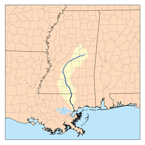
The Pearl River makes her way from a confluence of sloughy waters in the very heart of Mississippi to the marshy outskirts of the Gulf of Mexico in a graceful 500-mile arc. Lacking the majesty of the Mississippi, the cachet of the Yazoo or the utility of the Tombigbee, the Pearl is often cast as a poor relation; but she has played a significant role in Mississippi history, not the least of which has been putting Jackson on the map. In 1821, state commissioners decided that there was no desirable location within the required 20-mile limits of the geographic center of the state for the new seat of government, so they recommended a site “above the floods” of the Pearl River. In their report to the Legislature, the commissioners recommended the location of the new capital on LeFleur’s Bluff. They also suggested that the town should be laid out in President Jefferson’s design, a checker-board plan that stretched no more than a mile westward from the crest of the bluff where the new capital building would stand.
Initially, the Pearl River served the city as one of its earliest routes to and from civilization. The 1830s were a high water mark in the role of the river as a resource and a reason for the city, but by 1845, rail traffic had been established, and then roads rolled in from all quarters of the compass. Gradually the river fell into abeyance as a platform of commerce for the burgeoning city. But soon the Pearl came to assume a different economic role in the history of Jackson; the bluff could no longer accommodate all of its citizens and buildings began to be erected upon the floodplain. Flooding along the Pearl River in the Jackson area has been a problem since the beginning of the city, but it has been especially noticeable since development has spread into the floodplain. Since then, the river and its urban tributaries have flooded different areas on a periodic basis. Major floods have been classified by their severity according to the frequency at which they are estimated to occur. The 1979 flood has been called a 100-year floodplain event. The 1983 flood was a 50-year event. And the 1991 flood was a 10-year event. It should not pass without notice that all three of these events occurred within a 12-year period.
Reservoir spillway under construction, c. 1960
Ironically enough, given this catastrophe of riches in terms of water, area leaders were discussing the problems of an adequate drinking water supply for Jackson as early as 1926. One of these leaders was State Senator Mitchell Robinson who succeeded in obtaining a flood control and navigability study from the U.S. Army Corps of Engineers. The study proved unfavorable, but Robinson was persistent. Some dismissed his idea of a dam north of Jackson on the Pearl to provide water and recreation for the city as “Mitch’s ditch,” others warmed to the idea. By 1955, Jackson’s water consumption had increased in excess of five times the rate of 1935 and pollution in the Pearl was a mounting problem. The labyrinth of legal and legislative problems and other obstacles that stood in the way of the construction of the Ross Barnett Reservoir are history now, and the reservoir is a pivotal element in the life of the city. But the Reservoir never was really designed for flood control; it was primarily constructed to create a water supply and to provide recreation. Despite that, the reservoir, because of its very nature as an impoundment of water, plays a crucial role in flood control in the lower river basin. According to Kenneth Griffin, general manager of the Pearl River Valley Water Supply District, the Ross Barnett Reservoir presents special problems in that area.
“One of the challenges, and one of the reasons this reservoir is so difficult to manage for flood control is that you have a huge watershed for this size river, this size of control structure,” Griffin said. “Regrettably, even with perfect hindsight, all you can do is to handle something like a 15- or 20-year event, depending upon when it comes. Certainly you can’t handle a hundred-hear or five-hundred year event,” Griffin added. “1979 was a really terrible flood, and we managed that one with very little in the way of rain gauges and stream gauges. We had manual rain gauges, cooperators that would simply call in the precipitation and we did not have any sophisticated software at that time. And even then, I think the people did a very good job, came very close to doing the best job possible.”
Local attorney Joe Kerley adds this footnote to the construction of the reservoir. “My Dad worked with the US Department of Agriculture, and was involved in the Rivers and Harbors organization. He attended meetings regarding the US Corps of Engineers and other federal and state entities involved in planning the reservoir. Our state could not fund a structure that would adequately control flooding. However, federal funds could have been provided so that the dam would be multi-purpose: flood prevention, drinking water and recreational. However, to obtain federal funding, the reservoir would have to be accessible to all citizens, black and white. Our legislature, as typical of the times, would not agree, and declined federal funding.
“Dad was livid about this,” Kerley said. “He saw the writing on the wall at that time and was sure the reservoir would ultimately accessible to all. There were many discussions about this at home in Hattiesburg, and with like-minded friends. But the legislature would not allow the federal funding, and this many decades we are still trying to figure out how to protect Jackson from the Pearl floods and the inadequate dam at the Rez.”
But even in the case of reservoirs that are designed to control flooding, the use of impoundments for this purpose has been discredited because of their downstream (and upstream) impact. Flood control reservoirs are set at a specific area in a drainage system to control flooding in an immediate area, but reservoirs impact rivers both above and below their dams. The LeFleur Lakes project is such an impoundment proposal intended to solve the flooding problems in the Jackson area in such a manner that “the attractiveness and growth potential of the metropolitan area would also be enhanced.” The proposal states that flood levels would be permanently lowered in the Jackson-to-Byram area by providing a better flow course for the passage of water and by reducing the rate of flow in the river and envisions the creation of a vital new waterfront district for the Jackson Metropolitan area.
Under the LeFleur Lakes proposal, large amounts of sand from beneath the numerous railroad and highway structures south of downtown Jackson would be excavated. This would be needed in order to provide the proper flow course through this area of the river. The study proposal maintains that existing levees and bridges presently block the river’s flow and back water up into Jackson homes and businesses. To accommodate the excavated material, the Flowood levee would be moved to the east and the dredged material would then be put in the middle of the newly formed lake. This would create a 600-acre island opposite downtown Jackson. North of Lakeland the dredged material would be placed on the east side of the newly formed lake. The newly-created land, an artificial island in the middle of the Pearl near where an extended High Street would stretch, would be accessed by bridges and by constructing interchanges of parkways and city streets over it and along the entire length of the 3000 acre lake. The LeFleur Lakes proposal states that “many roads and bridges are needed at this time to alleviate the metropolitan area’s traffic congestion,” and that both the traffic and flooding problems can be solved simultaneously and at less cost than plans for previous flood control, roads and bridges. The proposal also says that all the structures that flooded in the 1979 flood should be protected from another 100-year flood by the new lake and the improved reservoir discharge procedure. Additionally, the plan would provide that surveying be conducted in order to determine what structures exist in the various flood prone areas that would not be protected from a so-called 100-year flood. If any structures exist that need protection, auxiliary plans would be considered and, if warranted, additional protection would be extended to those structures.
The LeFleur Lakes plan would accelerate the flow course for the river by removing the trees from the very lowest level of the river floodplain (the river bottom land). This level would then be lowered another 5 feet with dredges and other earth-moving equipment, and then the entire 11-mile river course opposite Jackson would be made into a permanent lake. This lake would be necessary to prevent the redistribution of sand and silt and to prevent the regrowth of trees in the river flow course. Naturally, the Ross Barnett Reservoir would play a key role in the project’s success. According to Griffin, “The LeFleur Lakes plan includes two components. Obviously, the lakes themselves are proposed. But the other half of the plan involves some major operational plans in how the (current) reservoir is operated, specifically how the gates are operated.” LeFleur Lakes admits to other drawbacks, as well. For instance, under the proposal, levels in the Ross Barnett Reservoir, on two or three occasions each year, over a period of a day and a half, will fall one foot then rise again to their original level. According to the original Two Lakes website (now defunct), “Once every 25 years they (“Reservoir people”) would be warned to untie moorings and move boats because the level will be taken down below 295 feet. On the positive side, they would enjoy an extra one half to one foot of water in their boat slips” and “would be compensated by knowing that two thousand of their neighbors will never have to worry about their homes and businesses flooding again.” In addition, metal buildings at very low elevations would not be protected from another 1979 flood, but they would be compensated by “having protection from a 100-year flood on structures that probably will not last 100 years.” People who own land and camps on the river south of Jackson would experience “one or two” river bottom floods that they would not have had otherwise, but they would be compensated by the assurance that the new reservoir would have the capacity to take one foot of elevation off of every major flood that could occur in the area. “One foot off of the 1979 flood would have prevented much of the flooding that these people’s neighbors suffered in 1979.”
Supporters of LeFleur Lakes cite the need some sort of flood control and the availability of direct funding for a local agency to undertake the project. Federal commitment to flood control in the Jackson area does exist; otherwise the Corps would not have sought funding for a more thorough and inclusive system of levees, a proposal now called the Comprehensive Levee System of 1996. In April, 1988 the Pearl River Basin Development District asked the Corps of Engineers to initiate alternative flood control studies. The Corps received authorization and funding in February 1989. Federal funds were used for the reconnaissance study which was completed in June 1990. The District agreed to serve as local sponsor for the study for the Jackson Metro area, which took 54 months to complete and cost $3 million. The District provided one-half of this amount in cash and in-kind contributions. A feasibility cost-sharing agreement was signed in September 1991, and feasibility studies were initiated in October of the same year.
The Pearl River Feasibility Flood Control Study (a.k.a. the Comprehensive Levee Plan) was completed by the Corps of Engineers in February 1996. The Corps recommended the construction of 21 miles of new levees at a cost of $122 million. The local sponsor would be required to provide $38 million for the acquisition of land, easements, rights-of-way, relocations and disposal areas. Legislation enabling the Pearl River Basin Development District to serve as the local sponsor for the Flood Control Project was defeated in the 1995 and 1996 sessions of the Mississippi Legislature. The plan also included $30 million worth of recreation amenities and improvements, most of which would have been cost shared. Even before then, in 1984, the Corps also proposed a dry dam that would catch heavy flows from extreme rainfall events in the upper basin, events similar to those which caused the ’79 and ’83 floods. Called the Shoccoe Dam to be installed near Carthage, it was planned at a cost of $80.1 million ($24 million shared). It was identified by the Corps of Engineers as the most comprehensive flood control project for the Pearl Basin. But in October, 1984, the Mississippi House of Representatives defeated a bill authorizing the District to serve as the local sponsor for Shoccoe. Local opposition killed the funding measure, but many people still consider Shoccoe to be the best plan for flood control in the middle reaches of the Pearl.
Everybody has their favorite proposals. “As far as we know, the Comprehensive Levee System (proposed by the Corps) is still viable, but we’ll have to evaluate it again,” Walker said. “We will have to see if the levee alignment is still in place, and we’ll have to see if any development has gotten in the alignment and we’ll have to adjust it.”
“What we’re looking at are the levees and LeFleur Lakes. It’s probable that LeFleur Lakes might turn out different than what it is now. The final result might be some combination of lakes and the levee system. We have several of what we call milestones that we’ll reach as we go through the study. We’ll discuss these with the sponsors, since these will be decision points where we’ll decide whether we need to go forward or not. If we get to the point that something showed up as a “show-stopper,” we would have to evaluate with the Levee Board at that time whether we want to proceed with that plan or do something else. But we could not proceed without them being agreeable to that. There is a consensus that something needs to be done, but the question is what the plan is on how to control it. Public opinion is such that something is needed to control flooding, but we don’t know what the plan is. As to other proposals, as we go through the process, a sponsor will have to sponsor a study for other alternatives. With the proper sponsorship, other plans could be submitted.”
* * * * * * * * * *
The Pearl River Basin covers an area of about 7,800 square miles, comprising about 16 per cent of the state as a whole. From Neshoba County, the river flows southwesterly, eventually forming the boundary between Louisiana and Mississippi in the southern part of the basin and discharging into the Gulf of Mexico just north of New Orleans. Before the Pearl reaches the Gulf from Jackson, it still traverses some two hundred plus miles, and the lands along the lower river have already felt the impacts of impoundment and flood control in the Jackson Metro area. One of the most serious effects is that of bank erosion, which has been a crucial and continual problem since the development of the state. Andrew Whitehurst, a wildlife ecologist with the Mississippi Museum of Natural Science, is the author of the newly-published Mississippi Streamside Handbook, available as a free download from the Mississippi Department of Wildlife, Fisheries and Parks website. Whitehurst said that rivers are able to carry a great amount of sediment. But when a stream goes into a reservoir, it slows down and the energy of the water is dissipated. Much of the suspended material it carries drops out, and the water leaves the reservoir sediment-starved.
“A normal river will gather a suspended load from its bed and from whatever flows in from its tributaries and through normal bank erosion and moving sand bars around,” Whitehurst said. “Our river (the Pearl) is altered. The fact that the discharges can be abruptly stopped after a flood event makes the levels go up and down, so the banks become saturated during floods and when the water is quickly shut off and the level of the river channel drops, the banks can slough or heave.” Whitehurst points out that there are three well-known diadromous (migratory salt-to-freshwater) species that will be impacted by the dams: the American eel, the Alabama shad and the Gulf sturgeon. The maritime connection of the Pearl is another crucial element when flood control anywhere along the river is under consideration, since the wetlands that lie near the mouth of the Pearl are important to the seafood industries along the central Gulf. In a public hearing in Biloxi on March 11, coastal residents expressed concerns that LeFleur Lakes would damage the Coast, especially in terms of the area’s seafood industry. Gulf citizens were particularly worried that the project would reduce the amount of fresh water flowing into the Mississippi Sound, degrading its oyster beds and shrimp population. Lauren Thompson, of the Mississippi Department of Marine Resources, said, “Our concern is with reduced or increased salinity as well as with sediment and nutrient transport down the Pearl River. The reduced flow of nutrients and sediments down the Pearl can change the environmental conditions in the Mississippi Sound, affecting salinity and water quality.
“So it could have a negative impact on oysters, shrimp, blue crabs and finfish. Oysters, which can’t move, have a narrow salinity band. If the salinity is too high, predators come in; if the salinity is too low, the oysters close up, and if they stay closed for an extended period of time, they die.” Since the Pearl empties into the Gulf just north of New Orleans, the State of Louisiana is also keeping an eye on flood control along the river, as it will impact their seafood industry as well as salinity levels in LakePontchartrain.
The Pearl River levee system.
Apart from the Reservoir, flood control in the Jackson area is also managed by a system of levees built by the Corps of Engineers in the 1960s. These levees serve as buffers for the floodwaters and also funnel the flood downstream. Aside from emergency situations, the levees are largely maintained by local interests. Periodic inspections of maintenance are made by personnel from the U.S. Army Corps of Engineers and from local levee and drainage districts, in this case the Rankin Hinds Pearl River Flood and Drainage Control District, also known locally as the Levee Board. This board has been given broad powers to deal with flood control along the Pearl River in Rankin and Hinds Counties. The board is made up of the mayors of Richland, Pearl, Jackson and Flowood as well as the head of the Mississippi Development Authority, Leland Speed, in his role as representative of the Mississippi State Fair Commission. Robert Stockett Jr. represents Hinds County, and the chair, Billy Orr, represents Rankin County. The board itself is funded by the Boards of Supervisors of Rankin and Hinds Counties.
There are fourteen miles of levees in the Jackson area that protect flood lands in Flowood, practically all of Pearl and those in Richland. They also protect those lands below the bluff around the fairgrounds on the Hinds County side of the river. The levee board has taxing power on property that is protected by the levees. If you own a business or property that is protected by a levee, then you are taxed by the Board to help pay for the maintenance of the levees as well as pump maintenance and levee patrols during flood times. The tax revenue brought in by the Board totals less than a half million dollars. The Corps and the Levee Board have agreed to initiate a three-year, $2.8 million feasibility study that will be limited to updating the cost of the 1996 levee plan and a complete analysis of the LeFleur Lakes Plan. “We don’t have a set schedule for reviewing the progress of the analysis,” Orr said, “We have other things to do, but the Corps will be on it daily and we’ll keep up with it very often. We do keep up to date on it, and it is our responsibility to make sure it goes right. Whatever the requirements are as these studies go along, we will meet as often as necessary.” Orr said that they follow the Corps’s recommendations in matters of maintaining the levees and that while some people might claim that they are more partial to one flood control plan over the other, “We will be partial to LeFleur Lakes only when it has been studied and it has been proven that it can do the job.”
The decision to put the LeFleur Lakes Plan in the hands of the Levee Board was made by the three county governments of Rankin, Hinds and Madison Counties as well as the governing bodies of eleven cities in the three county areas. Purportedly, they will expand the district and build some version of the project. The levees will be incorporated into the LeFleur Lakes strategy, since the levees were part of the original “Two Lakes” plan. According to Gary Walker, project manager for the Corps of Engineers, “The EIS (environment impact statement) draft (for LeFleur Lakes) is scheduled for October, 2005 and it will take about six months after that for the final. The recommendation will be a joint process between us and the sponsor,” Walker said. “It will be a plan we both can agree on, it will be a joint recommendation between us and the Rankin-Hinds Pearl River Flood and Drainage Control District. We’re doing a full evaluation and the study will determine how we assess the project. We’re not going to make any pre-determined notions. The study will speak for itself.”
As to alternatives to LeFleur Lakes and the comprehensive levee plans, no others are under consideration, since Walker said that the Corps can’t recommend anything without a sponsor. But “assuming we went through the process and found a feasible plan and a sponsor, yes, we could approve (an alternative).”
“People ask how long it will be before a flood control plan will be put into place,” Orr said. “But we don’t know how long it will take. The study itself is going to take two and a half years. After that, it would be left up to funds that are available, and this project (LeFleur Lakes) is big. Now, it might not come to anything, because environmental concerns might knock it down or something else like public sentiment or lack of funding might come into play. The only thing I can say is that this board would like for the LeFleur Lakes project to be a reality if it does the job in controlling flooding. The only thing we’re interested in is flooding. Economic development and all the other factors do not interest us. Our job is flood control, and if this project does not meet the required specifications, it will be gone. I’m sure there’s room for modification,” Orr said. “With all the study and money going into this, we hope something will come out of it that will work. The only thing for sure is that Rankin and Hinds Counties need some flood control assistance somewhere. I was head of the Fair Commission in 1979 during the Easter Flood and we lost over $2.5 million, and that’s a lot of money.”
* * * * * * * * * *
In the final analysis, until people begin to perceive of the Pearl as a resource rather than as an obstacle, LeFleur Lakes, or some similar project involving development along the river that will control flooding and perhaps create revenue, will continue to receive a lot of support in the Jackson Metro area. But we do have other choices. Metro Jackson can either preserve the riverfront with options that have the potential to appeal to a younger, more aggressive entrepreneurial population while continuing to promote more downtown development, or the city can align itself with political and business leaders who seek to develop the riverfront at great expense and create a new district that will in all likelihood fail within the next decade or so, benefiting nobody save those who developed (or dredged up) the property in the first place. Supporters say the LeFleur Lakes idea is just a different approach from the levees, one which has the economic development and recreational components that levees just don’t have. They also cite the support of local governments, state agencies and the congressional delegation. John McGowan, the Jackson entrepreneur who originally conceived of the LeFleur Lakes (then called Two Lakes) plan, declined to comment on the evaluation in a telephone interview and deferred comments on the project to the Levee Board.
Detractors of LeFleur Lakes tend to focus on the negative environmental impact the project will have, but not necessarily in the sense that it will endanger already threatened species of wildlife. These detractors cite numerous studies showing that in addition to education and other quality-of-life issues, aesthetics and recreation are important to young entrepreneurs, especially younger business owners who are looking to relocate. They point out that LeFleur Lakes is going to destroy the wetlands and natural resources that are in the corridor, the same resources that in other parts of the country, smaller urban areas use to provide green space for recreational opportunities that appeal to people oriented towards activities carried out in natural settings, like hiking, biking, jogging and nature viewing.
Pearl River swampland
These critics feel that the LeFleur Lakes project is simply not progressive enough and does not address the changing demographics and mindset of the 21st century South. In this context, the controversy surrounding LeFleur Lakes becomes a conflict of perception about the way Jackson should move, about the best venues that the city can take in order to become a more vibrant community rather than a battle between tree cutters and tree huggers. As an alternative to both LeFleur Lakes and the comprehensive levee system (which unlike LeFleur Lakes included green space facilities), proponents of green space, who include local businessmen as well as conservationists, are proposing a greenway that will transform what is now a denuded floodplain into an area that will feature hiking, biking and jogging trails, parks with sports fields and playgrounds, a scenic river corridor for boating as well as wilderness areas. Jackson geologist Dan Hill is among those who maintain that the greenway proposal has the potential to increase city revenue by attracting young professionals and entrepreneurs who look for such things as aesthetics and outdoor recreational activities when seeking to relocate. “The Levee Board has denuded the area between the levees to improve the convenience of the flood waters out of the flood zone,” Hill said. “The Levee Board maintains the levees and the floodways such as the areas at Lakeland and I-20. They clear the floodways rather than do any aesthetic features and it’s ugly.”
“When you clear the trees away from the river, there are no roots to hold the banks,” Hill said. “The reason they clear the trees is that those trees and vegetation create a drag on the water going through, so what they do is straighten up and dredge the channel as it has been along I-55. That improves the passage of water. One of the things that the Mississippi Department of Wildlife, Fisheries and Parks didn’t like was the clearings in the 1996 plan, which would have increased the number of clearings. It’s ugly; it looks like a moonscape going across I-20. And this creates a negative impression about Jackson.”
The greenway proposal is problematic because it can’t control flooding along the river and has limited appeal for those who are unaccustomed to more nature-oriented forms of activity (biking, hiking, kayaking, etc.) and are more acclimated to the hustle and bustle of a more people-oriented environment; shopping malls, for instance. But the environmental issues are still crucial. Water quality is a primary concern. According to Jackson businessman Jerry Litton, “If you look at the area that will be draining into LeFleur Lakes and look at the trash and debris that flushes from the city every time we have a rain, that is what the water in those lakes is going to look like.”
“Debris will collect on the edges of the lake, or collect on drifts that are out in the open or on the edges of the (proposed) island,” Litton said. “It’s going to be there, and somebody’s going to have to float around in a boat in a net and dredge it out, all of the stuff that comes down from the spillway itself, plus what flushes out of the creeks in the city.” Nonpoint pollution is also a consideration. Nonpoint pollution is source pollution, or “polluted runoff,” created when rain, irrigation and other water sources run over the land, picking up pollutants and transporting them to local water bodies. You’re going to hold water there in a large volume, and you’re going to have all the nonpoint pollutants that come from the city. Nonpoint sources are parking lots and roadways and fields. Then what about all the motor oil, paint and paint thinners that people won’t take the time to take to the toxic waste centers? It’s being poured down storm drains.”
Hill agrees. “The shallowness of the proposed reservoirs (LeFleur Lakes) is such that water temperature is going to heat up and that’s going to affect water quality. Not only that, but when they impound the lake they’re going to flood one landfill that I know of, and there’s probably a second landfill. I found out when they tore down the old Baptist hospital, they put the asbestos from that in a fill that would be flooded.” Sewer mains are another concern for the LeFleur Lakes project. Broken sewer mains would flow directly into the lake from the city. One such sewer is the West Main Intercept, which drains north Jackson and travels through the floodway. The construction of a lake in the floodplain opposite Jackson would put that sewer main underneath the lake itself. Environmental issues aside, when it comes to local sentiment, the LeFleur Lakes proposal appeals to a genuine need for the people of Jackson to feel as if they are living in a vibrant, growing community that is making changes and improvements. In addition to the attractions of proposed flood control and potential economic benefits, LeFleur Lakes has come to represent an alternative to apparently ineffective downtown development. Granted, LeFleur Lakes appeals more to the outlying metro area than it does to the city itself; on the surface, the project has much greater appeal for those sections of Ridgeland, Hinds and Rankin Counties between the spillway and Byram, but it still has its supporters in the city itself, not the least of which is former Jackson mayor Harvey Johnson Jr.
“The continuing flooding we experience nearly every year undeniably demonstrates that we very much need a comprehensive flood protection plan,” Johnson said. “As a member of the Rankin-Hinds Levee Board, I work closely with mayors from Rankin County and other board members to address ongoing flood control measures.”
“The public has rallied around the LeFleur Lakes project as an alternative to levees. The City of Jackson has gone on record as being in support of the LeFleur Lakes project, and we continue to work closely with federal, state and other local authorities to come up with the right answer to solve our problems with floods. We will continue to evaluate the LeFleur Lakes proposal as it evolves while we decide the best ways to provide flood control,” Johnson added.
“The problem with any development on the Pearl is hydraulics,” Litton adds. “Up to 1959 – 60 the river mostly only rose up to 28 or so feet crest. After the resevoir was built and levees it has gone up to 43 or so feet. Problem with this is it does not go up appreciably in the upper and lower reach as it does here. Why? Levees, reservoir, urban development and the unknow fact, the Pearl has a fifty or so mile long crest when it gets up. Check the data or the 79 floor. From the dam to about Rockport the crest was almost flat at 43 feet. Oddity, no sir, it is the hydrological sequence of hard bottom, forest shouldered edges, a narrow girth and the necessity for the river to get up this high to push the water through.”
But according to Matthew Dalbey, assistant professor in the Department of Urban and Regional Planning at Jackson State University, “From a physical planning point or perspective, when you have an interstate between a new development project and downtown, I don’t see how that is going to help downtown. As a matter of fact, I think it’s going to make downtown dead. It’s just too big of a separation; it’s just like any other type of leap-frog development or urban sprawl. The people who argue for this will say that any new development within the boundaries of the city will provide a positive economic impact, but the issue remains that the new development will be separate from the old development. It will kill downtown because of the separation. I think that there’s a tendency to support new development by local people, so for instance you can get a premium rate for something new whether it’s strategically located or not. In other words, there’s nothing new downtown, so people aren’t investing downtown, but take the Fondren Corner building; it’s a redone building in an area that had formerly been in decline,” Dalbey said. “But the new investment in that place has been such that they can get a premium on the rents there. As a matter of fact, Fondren is in a rebound, and people like being there.”
Of course, it’s questionable whether LeFleur Lakes, or any such new development district will improve the local economy. Some people are of the opinion that the city has extended itself already and that further development is superfluous; after all, the state economy is drawing back, consolidating itself and trimming edges, so it makes sense that the capital city should follow suit. Under scrutiny, LeFleur Lakes appears to be an antiquated development concept that creates more problems both in Jackson and downstream than it solves. Jackson deserves a solution to flooding that is effective and progressive, one that focuses on enduring issues rather than quick-fix alternatives. We need protect ourselves, but we need to take care of our river, too; after all, she’s why we’re here in the first place.
Cheese balls constitute an inevitability during any given holiday. Slapped atop one of those cutesy little carving boards that have a little two-pronged knife on a chain and surrounded by captain’s wafers, Ritz crackers or—at the New Year’s keg party—saltines, the cheese ball has become an entrenched feature of the American holiday table.
In their primitive state, Cheese balls first became manifest in the White House. Do try not to be too surprised. The first executive cheese ball was crafted by Elder John Leland of Cheshire, Massachusetts in 1801. Purportedly the Baptist community of Cheshire donated milk from over 900 cows to make a 1,235 pound ball known as “The Mammoth Cheese.”
Preaching all the way to Washington (some things never change), he transported the ball by wagon and then rolled it across the White House lawn to serve it to President Jefferson. Rumor has it that this ball of cheese lasted for two years until Jefferson finally had the remains thrown into the Potomac.
Then in 1835 dairy farmer Colonel Thomas S. Meacham of Sandy Creek, NY, crafted a titanic cheddar four feet in diameter, two feet thick and weighing nearly 1,400 pounds wrapped in a colossal belt bearing patriotic inscriptions for President Jackson . This cheese lasted so long that Jackson’s successor, Van Beuren, had to rip out the curtains in the “cheese room” and have the walls sanded and whitewashed.
Cheese balls as we know them first appeared in 1944 at patriotically modest gatherings. A columnist for the The Minneapolis Star, Virginia Safford—who aspired to “eat her way around the world”—chronicled culinary Minneapolis in Food of My Friends, and describes a cheese ball made by a Mrs. Selmber E. Ellertson. Stafford’s follow-up book, Friends and their Food (1969), features recipes for “Cheese in the Round” and “Cheese Rolls.”
The cheese ball really found its place in the 1970s, but–like disco and lava lamps–eventually developed a bad rap. Writing in 2003, New York Times food writer Amanda Hesser wrote, “Cheese balls tend to be associated with shag rugs and tinsel, symbols of the middle-class middlebrow.”
What with all the artisan cheeses flooding the market nowadays in addition–I like to think–with some degree of nostalgia for bell-bottoms and bean bags, cheese balls are making somewhat of a comeback. They’re a nice nosh, after all, and with some degree of restraint make a minimal impact upon the drapery. Options are endless, but most cheese balls are savory rather than sweet. Here is a classic recipe from Standing Room Only, a cookbook for entertaining published by New Stage Theatre in 1983.
1 pound cream cheese, softened, 2 tablespoons finely minced onion 1 4-oz. jar chopped mushrooms, drained 1 4-oz. jar chopped pimento, drained 1/2 cup finely chopped ripe olives 1/4 cup chopped green olives 1/2 cup grated sharp cheddar 1/4 cup Worcestershire Finely chopped nuts for coating
Mix all ingredients, chill overnight, then shape into a ball and roll in finely chopped nuts. Wrap and refrigerate overnight before serving.
After over forty years and $25 million, the prospect of transforming Farish Street into an urban oasis of bright lights, great food and memorable music has lost its luster.
In January 1980, a month before Farish Street was listed on the National Register of Historic Places, the city of Jackson launched plans to revive the area by making a contract with the National Business League for a $200,000 revitalization study. The contract as well as the cost of its extension a year later (an additional $34,000), was paid out of a Community Development Block Grant (CDBG) from the U.S. Department of Housing and Urban Development. The result of this study was the city’s ambitious 1984 Farish Street Revitalization Plan, which proposed to restore commercial and cultural activity in the district by enforcing codes, upgrading the infrastructure, improving housing and constructing a park between Farish and Mill streets. These improvements were to take place over a five-year period, but by 1989, the effort had failed; businesses had not moved into the area, crime was rampant and what housing existed was substandard.
But the revitalization of Farish Street retained its glamour, and in 1999, by far the largest infusion of money came from the State of Mississippi and Fannie Mae, $6 million from each. This money went to upgrade the infrastructure of the historic district, which began in 2002, the same year the city signed a contract with Performa Real Estate to develop the area at an estimated cost of $20 million. Six years later, Performa left the city after a bitter imbroglio with Mayor Frank Melton.
*(Community Development Block Grant – HUD) (Not included in this document are amounts for donations of real estate (e.g.: from state of Mississippi; donation of Alamo from Sunburst Bank), funding for the Smith-Robertson Museum and contract fees paid to Performa Entertainment and subsequent developers, among other costs.) 1) Hester, Lea Ann. “City expected to extend study of Farish Street.” The Clarion-Ledger 19 October 1981: 1B. Print. 2) Ibid. 3) Hester, Lea Ann. “Farish: Older than thought?” The Clarion-Ledger 23 July 1801: 1B. Print. 4) Scruggs, Afi-Odelia E. “Development plan fails to revitalize Farish Street.” The Clarion-Ledger 10 December 1989: 1A. Print. 5) Ibid. 6) Simmons, Grace. “Farish Street consultants to share info.” The Clarion-Ledger 9 October 1993: (no page cited) 7) Gates, Jimmie. “Renovation closer for Farish Street’s Alamo Theatre.” The Clarion-Ledger 22 November 1995: (no page cited) 8) Harris, Barbara. The Jackson Advocate. “Farish Street Historic District gets infusion of national, state funding.” 7 March 1996: 1A. Print. 9) Ibid. 10) Fleming, Eric. “Farish Street renovation under way.” The Mississippi Link. 26 March 1998. 1A: Print. 11) Henderson, Monique H. “Draft document targets Farish St. Historic District:12M allotted for development of district.” The Clarion-Ledger. 27 April 1999. 1B Print. 12) Ibid. 13) Mayer, Greg. “$1.5M grant going to Farish Street.” The Clarion-Ledger. 22 March 2001. 1B: Print. 14) Ibid. 15) _______. “Black museum receives grant.” The Picayune Item. 12 January 2000. (no page cited) 16) Mitchell, Jerry. “$2M-plus in grants awarded to state civil rights sites.” (“$210,000 will help stabilize the foundation and repair the Medgar Evers House Museum in Jackson.”) The Clarion-Ledger. 3 August 2011. (no page cited)
Prospective investors have been discouraged by the unaccountability of financed development in the area, particularly by the Farish Street Historic District Neighborhood Foundation, the steering organization for the revitalization project, which was founded in 1980, moved to the Office of City Planning in 1995 and disappeared (along with its documentation) in 2006. The ensuing decade brought diminishing appeals for Farish revitalization, and in 2015, Mayor Tony Yarber, faced with what was to become a chronic city-wide breakdown of essential infrastructure, stated in 2015 that the project was “on the back burner”.
Once considered the keystone project towards the revitalization of decaying downtown Jackson, Farish Street has instead become a byword for boondoggle and corruption as well as a forlorn Potemkin village in the heart of the city.
It’s ugly, no damn good for you, and looks like a flaming asshole.
Take a pound of frozen tater tots (the brand doesn’t matter; a frozen grated potato is a frozen grated potato) and cook according to package directions. It’s best to use the “fry” option, since the more grease the better.
Fry a half-pound of bacon or cube a half-pound of ham, or do both. This recipe should include LOTS and LOTS of pork.
Stir the tater tots and pork together with a half cup mayonnaise and two cups grated American cheese or Velveeta. Grease a Bundt pan with lard.
Pack the tots, pig, and cheese into the pan. Bake for about forty-five minutes at 375. Invert and serve.
These selections from Imani Perry’s South to America (Ecco; January 25, 2022) join earlier excerpts from V.S. Naipaul’s A Turn in the South and Joan Didion’s South and West to exhibit how others from outside the American South perceive both the region in general and Mississippi in specifics.
Perry’s work echoes Naipaul’s in scope and form (in fact, she read A Turn in the South to prepare herself for the project), but her work is more perceptive, learned, certain, and above all determined.
Many will find South to America as provocative as it is ambitious. Perry maintains that race is “at the heart of the South, and at the heart of the nation,” and that “the country has leeched off the racialized exploitation of the South while also denying it.” These selections provide the reader with a radical perspective on the South, and most specifically on Jackson, Mississippi, which she says is “publicly, unapologetically Black.” While many will be surprised to hear Jackson’s Mayor Lumumba referred to as a “scion of Black nationalism,” it’s certainly nothing new.
I HEARD HIS VOICE OVER the PA in the airport and I wet my eyes. “I am Chokwe Antar Lumumba,” the mayor of Jackson welcomes you when you arrive.
He is one of a growing number of young Black Southern mayors, Mayor Lumumba, like my uncle Cornelius, went to Tuskegee for college and Texas Southern for law school. He was nurtured in the tradition of HBCUs. And he is a scion. Sons have a certain importance, culturally. Patriarchy, that fundamental structure of the West, was denied to Black people during slavery and has remained fragile ever since.
Money, protection, domestic authority–these are elusive, though cherished things in the face of poverty and prison. As much as I have written about escaping from patriarchy’s hold, I can’t pretend to not understand the deep yearning for a son to take on the leadership role of the father when it comes to Black people.
In Jackson the mayor’s father, the elder Chokwe Lumumba, had spent decades in the service of the freedom movement. The attorney for revolutionary Black activists of the Black Power movement like Assata Shakur and Nehanda Abiodun, he was also a leader of NAPO, the New Afrikan People’s Organization and notably carried a chosen surname that was the same as that of Patrice Lumumba, the Congolese anticolonialist movement leader who had been murdered in 1961 by Belgian and US forces.
NAPO was a coming together of different communities in the New Afrikan Independence Movement. The Republic of New Afrika was imagined in 1968 as an independent Black-majority nation in the Southeastern United States. The first vision was articulated at a meeting of the Malcolm X Society in Detroit. The states they imagined as being part of this new nation: Louisiana, Mississippi, Alabama, Georgia, and South Carolina. They shared goals of self-determination, landownership, and an independent nation-state for New Afrikans, who were colonized by US imperialism, in line with the older Black Belt theory. They believed in Democratic centralism, socialism, and reparations, as well as humility and self-defense.
The elder Lumumba was elected to the Jackson city council in 2009, and then to the office of mayor in 2013. He died under mysterious circumstances soon thereafter. The latter two events were national news, but I’d heard about the elder Lumumba repeatedly from my parents and their friends of his brilliance, courage, and commitment to the struggle” to “free the land.” And now here was the voice of his son, bearing a shared name, welcoming us to Jackson.
Jackson is urban, but it is also country. Naipaul referred to it as “the frontier” It was where he was introduced to the classic architecture of the Deep South “There were streets of ‘shotgun’ houses. It was the first time I had ever heard the expressive word: narrow wooden houses (like mobile homes or old-fashioned railway carriages) with the front room opening into the back room and with the front door and back door aligned.
On Sunday afternoon the people were out on the streets, so that the effect of crowd and slum and blackness was immediate: as though outdoor life, life outside the houses, was an aspect of poverty.” I wouldn’t call Jackson the frontier, but it might be something else: a sort of reverse metropole, a substation of the people.
The generations of freedom fighters in the Black Belt continue their work. And in Mississippi, they have made it the state with the most extensive Black political representation in America. It is the closest we have to a realization of full Black political citizenship. And it is the only state with a scion of Black nationalism as the executive of its capital.
Jackson is publicly, unapologetically Black, even for Mississippi. It evidences itself in culture as much as polities. For example, the marching band at Jackson State University is called the Sonic Boom of the South. When the male dancers jump, in navy and white so crisp it could not have possibly touched dirt or concrete for how pristine it is, they are suspended in air, time stands still, and yet the music goes hard and unceasingly.
When the women dancers dash a hip, to left, to right, it is sharp, taking back the lasciviousness teased in an instant, a taste before magisterial precision; as the horns gleam, the musicians are consistent as seasons of crops. They march, left right left right. The band does not make the flesh crawl; it revels in it. Love this flesh, it says. It makes sense that this is where the great chronicler of Black history in poem and fiction and prose Margaret Walker made her home as a professor at Jackson State University. She was one who saw the glory of the eternal coming of Black people. The exultation.
They march through the streets, not just in stadiums, and you can always see the dirt high-stepping underfoot. There is no easy resolution between beauty and terror, between poverty and abundance.
And just outside of the city, you find yourself looking around and saying the South would be worth holding close even if only for the trees. You can see it. How before all the building, the Piney Woods once stretched across five states. And as chopped down as they are now, their sharp warm scent and sight wraps around you even when you’re standing from a distance. They emanate fragrance that you feel in your eye sockets and above your socks. They are a fortification against climate change. The scientists say these trees are in a desperate battle against human green, slowing the pace of destruction by literally killing greenhouse gases with their scent, If only we were willing to reblanket the Southeast in conifers, we might save ourselves.
The interior rotunda in the seat of Mississippi government has a statue of the blind goddess Justice lit by over seven hundred lights. Around her are two Indigenous people, a European explorer, and a Confederate soldier. There is no African. Look up at the top of the gold leaf copper dome and see our national symbols a white-headed bald eagle.
We haven’t outrun or outlived the plantation, although it looks a little bit different. Now the fugitives are from Central America and the unfree laborers are in prison. Some kids are still hungry, even so many years after the breakfast programs and Head Start and all of the gains fought for by Black elected officials, because the gag is in the money and the land, and it still isn’t free.
There’s an honesty to Mississippi about all of this. The triumph is not in ends; it is in the fact that we are still here.
Most state flags were adopted between 1893 and World War I. Texas is an exception, her flag a holdover from the Republic of Texas (1836-46), but the Lone Star was itself adopted from an earlier flag, the Bonnie Blue flag of the Republic of West Florida. After a failed rebellion against Spain in 1802, American settlers in the coastal South revolted successfully in 1810. The Republic of West Florida was organized, a constitution adopted, officials were elected and application was made to President Madison for admission to the Union. Madison declared the republic a part of the Louisiana Purchase and ordered Louisiana Governor Claiborne to take possession. The Republic of West Florida’s flag had a blue background bearing a single white star that in time became known as the Bonnie Blue Flag. This flag flew over Baton Rouge, Pass Christian and Pascagoula for a short time and reappeared as the Lone Star in the flag of Texas.
When Mississippi seceded from the Union on January 9, 1861, the Bonnie Blue was widely recognized as the unofficial flag of the Confederacy; it was raised over Ft. Sumter as well as the capitol building in Jackson. On January 26, Mississippi officially adopted a state flag which included a canton with the Bonnie Blue star and a magnolia tree in a white center field with a red border. This flag, usually depicted without the red border but with a red bar on the right, is now widely known as the Magnolia Flag. The Bonnie Blue remains an icon of the Confederacy, an image that while lesser-known in our day was just as emblematic as the battle flag to contemporaries. Take note that Scarlett and Rhett had their daughter baptized as “Eugenia Victoria Butler”, but she was called “Bonnie Blue”.
In November 1861 the Confederacy adopted an official flag, the “Stars and Bars”, a flag so closely resembling the Union flag that in the Battle of Manassas in July, 1861, Confederate forces fired on their own troops. General Beauregard, commander of the Army of Northern Virginia, decided that a change must be made and in cooperation with General Johnston and Quartermaster General Cabell, they issued a flag designed by William Porcher Miles, a broad blue saltire on a red field, bordered with white and emblazoned with thirteen five-pointed stars. This design became known as the battle flag, and was later incorporated in flags adopted by the Confederacy in 1863 and 1865. The Magnolia Flag remained in use as the state flag of Mississippi until 1894, when a new one with the Confederate battle flag in the canton and a field of blue, white and red bars was adopted by the Mississippi Legislature. The only change since then has been the addition of a white border separating the canton from the blue and red bars; the original specifications were vague, and the flag was made in versions with and without the border until Governor Fordice issued an executive order requiring its use in 1995.
In 2000, the Supreme Court of Mississippi ruled that state legislation in 1906 had repealed the adoption of the flag in 1894, so what was considered to be the official flag was only so through “custom and usage”. Governor Musgrove appointed an independent commission that developed a design replacing the Confederate battle flag with a blue canton containing 20 stars representing Mississippi’s status as the 20th state admitted to the Union. The proposed flag, with the exception of a single undistinguished star in the inner circle of six signifying the state’s membership in the Confederacy among five other sovereign nations (the others representing France, the Republic of Mississippi, Spain, the United Kingdom and the United States), had no outstanding symbolic reference to the Confederate States of America. On April 17, 2001, a non-binding state referendum to change the flag was put before Mississippi voters. The new design was defeated in a vote of 64% (488,630 votes) to 36% (267,812).
On February 27, 2013, the beaten and burned body of Marco McMillian, the first “viable” openly gay candidate for public office in Mississippi, was found near a levee in rural Coahoma County, almost thirty-five years after Harvey Milk was assassinated in San Francisco.
“Breaking Through” (www.breakingthroughmovie.com) documents the brutal struggle of gay, lesbian and transgender American citizens for the acknowledgement of their basic civil rights, more specifically their ongoing efforts to find open representation and responsibilities in the political arena. This film provides the stories of men and women who occupy positions of leadership in public service by having overcome both overt and embedded obstacles. As these people speak, historic newspaper headlines and photographs flash across the screen, emphasizing antagonism and threats yet stopping well short of the ruthless details of murders, beatings and ostracism which could easily have been offered. The camera cuts from left to right in the interviews as these people tell of being open but not publicly open, of living life half-in, half-out, describing the crippling limitations homophobia held for them and still holds for present and future Americans.
These stories provide a record of the challenges inherent in everyone’s desire to be a member of the family of mankind. See this documentary, and as you watch it, bear Marco McMillian in mind. The struggle isn’t over; not by a long shot.